IMAGES TAKEN NEAR TO
Tromra Road, BALLYMENA, BT44 0SU
Introduction
This page details the photographs taken nearby to Tromra Road, BT44 0SU by members of the Geograph project.
The Geograph project started in 2005 with the aim of publishing, organising and preserving representative images for every square kilometre of Great Britain, Ireland and the Isle of Man.

There are currently over 7.5m images from over14,400 individuals and you can help contribute to the project by visiting https://www.geograph.org.uk
Image Map
Images are licensed for reuse under creativecommons.org/licenses/by-sa/2.0
Notes
- Clicking on the map will re-center to the selected point.
- The higher the marker number, the further away the image location is from the centre of the postcode.
Image Listing (19 Images Found)
Images are licensed for reuse under creativecommons.org/licenses/by-sa/2.0
Image
Details
Distance
1
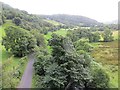
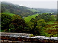
Glendun Road and River
Downstream view from the viaduct.
Image: © Richard Webb
Taken: 5 Aug 2013
0.14 miles
2
Loughareema Road crossing the Glendun Viaduct
The Glendun Viaduct spans the River Dun in the centre of the glen. It was built over a period of five years from 1834 to 1839 (http://www.ballycastle.info/places/Glendun/dunviaduct.htm more detailed information). One of its three arches spans the river and another the Glendun Road.
Image: © David Dixon
Taken: 28 Sep 2017
0.14 miles
3
Glendun Viaduct
Glendun Viaduct (known locally as “the Big Bridge”) spans the River Dun in the centre of the glen and is regarded by some as one of the finest buildings of its kind in the British Isles. It was built over a period of five years from 1834 to 1839 (http://www.ballycastle.info/places/Glendun/dunviaduct.htm more detailed information). One of the three arches spans the river and another the Glendun Road.
Image: © David Dixon
Taken: 28 Sep 2017
0.15 miles
4
![The Glendun Viaduct [1]](https://s0.geograph.org.uk/geophotos/04/55/78/4557880_9dbf2d58_120x120.jpg)
The Glendun Viaduct [1]
Approaching the viaduct from the minor road to Cushdun. The viaduct carries the A2 coast road over the River Dun and the minor road to Cushdun. The viaduct is listed, grade B, see: http://www.doeni.gov.uk/niea/content-databases-buildview?id=7013
Image: © Michael Dibb
Taken: 10 Jun 2015
0.15 miles
5
![Glendun Viaduct [2]](https://s3.geograph.org.uk/geophotos/04/55/78/4557887_f2bf1c93_120x120.jpg)
Glendun Viaduct [2]
Seen from the minor road to Cushdun. The viaduct carries the A2 coast road over the River Dun and the minor road to Cushdun. The viaduct is listed, grade B, see: http://www.doeni.gov.uk/niea/content-databases-buildview?id=7013
Image: © Michael Dibb
Taken: 10 Jun 2015
0.15 miles
6
![Glendun Viaduct [3]](https://s3.geograph.org.uk/geophotos/04/55/78/4557895_b9c050e1_120x120.jpg)
Glendun Viaduct [3]
The River Dun is seen here flowing past the Glendun Viaduct. The viaduct carries the A2 coast road over the River Dun and the minor road to Cushdun. The viaduct is listed, grade B, see: http://www.doeni.gov.uk/niea/content-databases-buildview?id=7013
Image: © Michael Dibb
Taken: 10 Jun 2015
0.15 miles
7
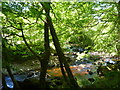
The River Dun
The river is seen here near the Glendun Viaduct.
Image: © Michael Dibb
Taken: 10 Jun 2015
0.15 miles
8
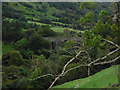
County Antrim Coast Road (A2) - Glendun Viaduct over Glendun River - Woodland
View is to the northeast toward Cuahleake Mountain from the Glendun Viaduct and Antrim Coast Road (A2), also known as Loughareema Road, (A2) over the Glendun River. Also shown is a portion of Glendun Road, which passes beneath the viaduct.
Image: © Suzanne Mischyshyn
Taken: 24 Sep 2013
0.15 miles
9
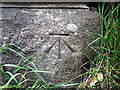
Bench Mark, Glendun Viaduct
Cut bench mark on the Glendun Viaduct. This one is at the foot of the viaduct on the Glendun Road Image - there are two further bench marks above on the Loughareema Road.
The mark is 26.67 metres above MSL.
See also http://www.geograph.org.uk/search.php?i=11037856 for many other examples I have found.
Image: © Rossographer
Taken: 19 Jun 2010
0.15 miles
10
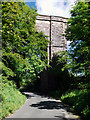
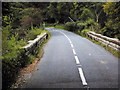
The Glendun Road
The Glendun Road heading towards Cushendun as it passes beneath the mighty Glendun Viaduct - see Image
Image: © Rossographer
Taken: 19 Jun 2010
0.16 miles