IMAGES TAKEN NEAR TO
Carn-Neil Park, BALLYMENA, BT44 0RH
Introduction
This page details the photographs taken nearby to Carn-Neil Park, BT44 0RH by members of the Geograph project.
The Geograph project started in 2005 with the aim of publishing, organising and preserving representative images for every square kilometre of Great Britain, Ireland and the Isle of Man.

There are currently over 7.5m images from over14,400 individuals and you can help contribute to the project by visiting https://www.geograph.org.uk
Image Map
Images are licensed for reuse under creativecommons.org/licenses/by-sa/2.0
Notes
- Clicking on the map will re-center to the selected point.
- The higher the marker number, the further away the image location is from the centre of the postcode.
Image Listing (29 Images Found)
Images are licensed for reuse under creativecommons.org/licenses/by-sa/2.0
Image
Details
Distance
1
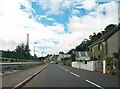
The lower end of Glenariff Road, Glenariff/Waterfoot
The barriers on the left are to stop motorists from ending in the Glenariff River.
Image: © Eric Jones
Taken: 13 Aug 2011
0.07 miles
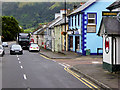
2
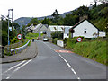
Waterfoot, Glenariff Road
Waterfoot is a small village on the Antrim coast which has a 1 mile-long beach at Red Bay, named from the reddish sand that washes from the exposed sandstone on the cliffs down to the shore. The village is at the foot of Glenariff, one of the Glens of Antrim (the village is also known as Glenariff). The 2001 Census recorded a population of 504 inhabitants (Wikipedia).
Image: © David Dixon
Taken: 28 Sep 2017
0.08 miles
3
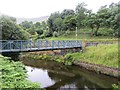
Footbridge, Waterfoot
A new bridge over the Glenariff River.
Image: © Richard Webb
Taken: 29 Jul 2013
0.08 miles
4
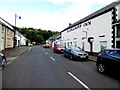
Glenariffe Road, Waterfoot
Looking north-west
Image: © Kenneth Allen
Taken: 16 Aug 2018
0.08 miles
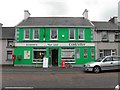
5
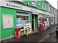
Kearney's
Shop and post office, Waterfoot
Image: © Richard Webb
Taken: 29 Jul 2013
0.08 miles
6
Waterfoot, Garron Road
Waterfoot is a small village on the Antrim coast which has a 1 mile-long beach at Red Bay, named from the reddish sand that washes from the exposed sandstone on the cliffs down to the shore. The village is at the foot of Glenariff, one of the Glens of Antrim (the village is also known as Glenariff). The 2001 Census recorded a population of 504 inhabitants (Wikipedia).
Image: © David Dixon
Taken: 28 Sep 2017
0.08 miles
7
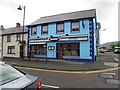
Stevies, Waterfoot
It is located at Main Street
Image: © Kenneth Allen
Taken: 29 Jun 2010
0.09 miles
8
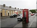
Telephone box, Waterfoot
Garron Road, Waterfoot. The village was quite lively and busy this evening.
Image: © Richard Webb
Taken: 29 Jul 2013
0.09 miles
9
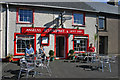
Angela's Restaurant, 32 Main Street, Waterfoot
Taken in 2006, by 2010 the road sign had moved and it became Image I'm not clear why there is a road sign here although from the satellite view it looks like the house opposite may have been a road at one time.
Image: © Jo and Steve Turner
Taken: 8 Sep 2006
0.09 miles
10
Costcutter, Waterfoot
It is located at Main Street
Image: © Kenneth Allen
Taken: 29 Jun 2010
0.09 miles