IMAGES TAKEN NEAR TO
Glen Road, BALLYMENA, BT44 0RG
Introduction
This page details the photographs taken nearby to Glen Road, BT44 0RG by members of the Geograph project.
The Geograph project started in 2005 with the aim of publishing, organising and preserving representative images for every square kilometre of Great Britain, Ireland and the Isle of Man.

There are currently over 7.5m images from over14,400 individuals and you can help contribute to the project by visiting https://www.geograph.org.uk
Image Map
Images are licensed for reuse under creativecommons.org/licenses/by-sa/2.0
Notes
- Clicking on the map will re-center to the selected point.
- The higher the marker number, the further away the image location is from the centre of the postcode.
Image Listing (7 Images Found)
Images are licensed for reuse under creativecommons.org/licenses/by-sa/2.0
Image
Details
Distance
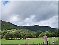
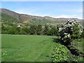
2
Glen Road, Craignagat
Heading SSW towards Diskirt
Image: © Kenneth Allen
Taken: 3 Jun 2010
0.05 miles
3
Craignagat Townland
Looking SSE towards Upper Glenariff
Image: © Kenneth Allen
Taken: 3 Jun 2010
0.06 miles
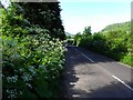
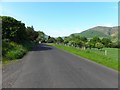
4
Glen Road
Heading NNE towards Tamlaght
Image: © Kenneth Allen
Taken: 3 Jun 2010
0.09 miles
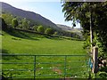
5
Craignagat Townland
Looking north-west in the direction of Glassmullen
Image: © Kenneth Allen
Taken: 3 Jun 2010
0.14 miles
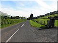
6
Glen Road, Greenaghan
Heading south-west towards Craignagat
Image: © Kenneth Allen
Taken: 3 Jun 2010
0.23 miles
7
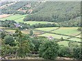
Callisnagh Bridge
View to the glen floor from Glenariffe Road.
Image: © Richard Webb
Taken: 29 Jul 2013
0.25 miles