IMAGES TAKEN NEAR TO
Layde Road, BALLYMENA, BT44 0LZ
Introduction
This page details the photographs taken nearby to Layde Road, BT44 0LZ by members of the Geograph project.
The Geograph project started in 2005 with the aim of publishing, organising and preserving representative images for every square kilometre of Great Britain, Ireland and the Isle of Man.

There are currently over 7.5m images from over14,400 individuals and you can help contribute to the project by visiting https://www.geograph.org.uk
Image Map
Images are licensed for reuse under creativecommons.org/licenses/by-sa/2.0
Notes
- Clicking on the map will re-center to the selected point.
- The higher the marker number, the further away the image location is from the centre of the postcode.
Image Listing (19 Images Found)
Images are licensed for reuse under creativecommons.org/licenses/by-sa/2.0
Image
Details
Distance
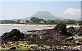
2
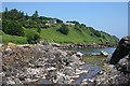
Salmon Rocks
The rocks here are conglomerates and volcaniclastics of the Cushendall Formation.
Image: © Anne Burgess
Taken: 7 Jun 2007
0.16 miles
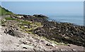
3
Salmon Rocks
An interesting outcrop of conglomerate and volcaniclastic rocks at the north end of Cushendall Bay, with Lurigethan in the distance.
Image: © Anne Burgess
Taken: 7 Jun 2007
0.16 miles
4
Salmon Rocks
The sediments of which these rocks are composed were deposited in a large channel about 400 million years ago.
Image: © Anne Burgess
Taken: 7 Jun 2007
0.16 miles
5
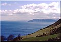
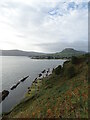
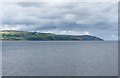
View of the Antrim Coast
Towards Cushendall
Image: © Anthony O'Neil
Taken: Unknown
0.17 miles

8
The coastline on the north side of Cushendall Bay
This view was taken from the beach east of Glenariff.
Image: © Eric Jones
Taken: 13 Aug 2011
0.20 miles