IMAGES TAKEN NEAR TO
Garron Road, BALLYMENA, BT44 0JN
Introduction
This page details the photographs taken nearby to Garron Road, BT44 0JN by members of the Geograph project.
The Geograph project started in 2005 with the aim of publishing, organising and preserving representative images for every square kilometre of Great Britain, Ireland and the Isle of Man.

There are currently over 7.5m images from over14,400 individuals and you can help contribute to the project by visiting https://www.geograph.org.uk
Image Map
Images are licensed for reuse under creativecommons.org/licenses/by-sa/2.0
Notes
- Clicking on the map will re-center to the selected point.
- The higher the marker number, the further away the image location is from the centre of the postcode.
Image Listing (6 Images Found)
Images are licensed for reuse under creativecommons.org/licenses/by-sa/2.0
Image
Details
Distance
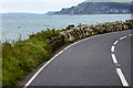
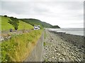
4
Turner's Point
Actually this is the shore north of Turner's Point, where the A2 road runs close to the shore.
Image: © Anne Burgess
Taken: 7 Jun 2007
0.21 miles
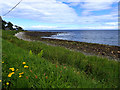
5
Carnlough, Turnly's Port
Looking towards Garron Point on the Causeway Coastal Route.
Image: © Mike Faherty
Taken: 20 Jun 2018
0.23 miles
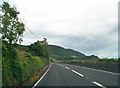
6
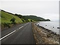
Garron Road, Loughan
The Antrim Coast Road (A2) on its raised beach.
Image: © Richard Webb
Taken: 29 Jul 2013
0.24 miles