IMAGES TAKEN NEAR TO
Largy Road, BALLYMENA, BT44 0JJ
Introduction
This page details the photographs taken nearby to Largy Road, BT44 0JJ by members of the Geograph project.
The Geograph project started in 2005 with the aim of publishing, organising and preserving representative images for every square kilometre of Great Britain, Ireland and the Isle of Man.

There are currently over 7.5m images from over14,400 individuals and you can help contribute to the project by visiting https://www.geograph.org.uk
Image Map
Images are licensed for reuse under creativecommons.org/licenses/by-sa/2.0
Notes
- Clicking on the map will re-center to the selected point.
- The higher the marker number, the further away the image location is from the centre of the postcode.
Image Listing (12 Images Found)
Images are licensed for reuse under creativecommons.org/licenses/by-sa/2.0
Image
Details
Distance
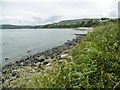
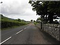
1
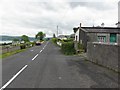
Largy Road
Heading SSW towards Carnlough
Image: © Kenneth Allen
Taken: 29 Jun 2010
0.09 miles
2
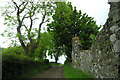
Country lane above Lemnalary
This tree lined, single track lane passes through farmland.
Image: © George Brown
Taken: 14 Jun 2009
0.09 miles
3
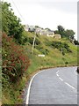
Garron Road
The Antrim Coast Road leaves Carnlough.
Image: © Richard Webb
Taken: 29 Jul 2013
0.10 miles
4
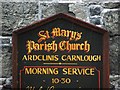
Notice board, St Mary's Church
It is located here Image]
Image: © Kenneth Allen
Taken: 29 Jun 2010
0.12 miles
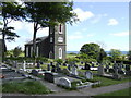
5
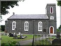
St Mary's Parish Church, Carnlough
It is located along Largy Road
Image: © Kenneth Allen
Taken: 29 Jun 2010
0.12 miles
6
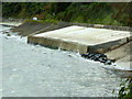
Concrete Sea Defences, Carnlough Bay
This section of the Antrim coast road is protected by concrete sections in several places.
Image: © David Dixon
Taken: 28 Sep 2017
0.12 miles
7
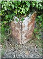
Old Milepost by the A2, Garron Road, Lemnalary
Cast iron milepost with iron attachments on the A2, in the townland of Lemnalary; Garron Road, Bottle Point opposite track against wall in ivy, West side of road. Erected by the county, C19.
Inscription reads:- : CUSHEN / DALL / 9¼ / MILES : : GLENARM / 4 / MILES : : BELFAST / 40 :
Milestone Society National ID: ANT_BFBC40.
Image: © Milestone Society
Taken: 20 Jun 2018
0.14 miles
9
Largy Road, Carnlough
Heading NNE towards the A2 Garron Road
Image: © Kenneth Allen
Taken: 29 Jun 2010
0.17 miles
10
St. Mary's church, Ardclinis, Carnlough
A grade B listed building that sits above the sea near Hunter's Point. Ailsa Craig can just be made out on the horizon between the tower and the tree to its right.
Image: © Jonathan Billinger
Taken: 14 May 2007
0.19 miles