IMAGES TAKEN NEAR TO
Marine Road, BALLYMENA, BT44 0HE
Introduction
This page details the photographs taken nearby to Marine Road, BT44 0HE by members of the Geograph project.
The Geograph project started in 2005 with the aim of publishing, organising and preserving representative images for every square kilometre of Great Britain, Ireland and the Isle of Man.

There are currently over 7.5m images from over14,400 individuals and you can help contribute to the project by visiting https://www.geograph.org.uk
Image Map
Images are licensed for reuse under creativecommons.org/licenses/by-sa/2.0
Notes
- Clicking on the map will re-center to the selected point.
- The higher the marker number, the further away the image location is from the centre of the postcode.
Image Listing (215 Images Found)
Images are licensed for reuse under creativecommons.org/licenses/by-sa/2.0
Image
Details
Distance
1
Londonderry Arms Hotel, Carnlough
Located at Harbour Road, more at http://www.glensofantrim.com/
Image: © Kenneth Allen
Taken: 2 Jun 2010
0.01 miles
2
Milepost, Carnlough
Old milepost on the coast road through Carnlough. This milepost records that Belfast is 39 miles away, Cushendall is 10.25 miles away and Glenarm is 3 miles away.
Image: © Rossographer
Taken: 30 Aug 2015
0.01 miles
3
Milepost, Carnlough
Old milepost on the coast road through Carnlough. This milepost records that Belfast is 39 miles away, Cushendall is 10.25 miles away and Glenarm is 3 miles away.
Image: © Rossographer
Taken: 30 Aug 2015
0.01 miles
4
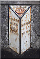
Milepost, Carnlough
Old milepost on the coast road through Carnlough. This milepost records that Belfast is 39 miles away, Cushendall is 10.25 miles away and Glenarm is 3 miles away.
Image: © Rossographer
Taken: 30 Aug 2015
0.01 miles
5
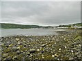
Carnlough Bay
Looking towards Glencloy.
Image: © Mike Faherty
Taken: 20 Jun 2018
0.02 miles
6
Currans, Carnlough
Seems to be closed; located along Harbour Road
Image: © Kenneth Allen
Taken: 2 Jul 2010
0.02 miles
7
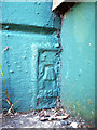
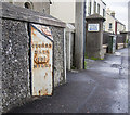
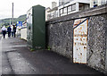
Flush Bracket, Carnlough
Flush bracket located on the front of a pharmacy on Bay Road, Carnlough. See Image - the bracket is on the extreme bottom right and is partially obscured by the wall.
The number on the bracket is OSBM 3428.
The mark is 3.92 metres above MSL.
A flush bracket is a type of bench mark set onto the face of a building. See also http://www.geograph.org.uk/search.php?i=11037856 for many other examples I have found.
Image: © Rossographer
Taken: 19 Jun 2010
0.02 miles
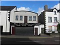
8
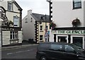
Carnlough, dining rooms
Bridge Dining Rooms, on Marine Road (A2, Causeway Coastal Route).
Image: © Mike Faherty
Taken: 20 Jun 2018
0.02 miles
9
Carnlough, Carnlough River
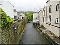
Looking upstream from Bridge Street, shortly before its joining the sea.
Image: © Mike Faherty
Taken: 20 Jun 2018
0.02 miles
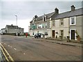
10
The junction of Bridge Street with the A2 (Harbour Road) at Carnlough
Image: © Eric Jones
Taken: 26 Sep 2013
0.02 miles