IMAGES TAKEN NEAR TO
Parkview Cottages, BALLYMENA, BT44 0DU
Introduction
This page details the photographs taken nearby to Parkview Cottages, BT44 0DU by members of the Geograph project.
The Geograph project started in 2005 with the aim of publishing, organising and preserving representative images for every square kilometre of Great Britain, Ireland and the Isle of Man.

There are currently over 7.5m images from over14,400 individuals and you can help contribute to the project by visiting https://www.geograph.org.uk
Image Map
Images are licensed for reuse under creativecommons.org/licenses/by-sa/2.0
Notes
- Clicking on the map will re-center to the selected point.
- The higher the marker number, the further away the image location is from the centre of the postcode.
Image Listing (6 Images Found)
Images are licensed for reuse under creativecommons.org/licenses/by-sa/2.0
Image
Details
Distance
1
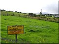
Aughnagash Townland
Looking past the sewage treatment area.
Image: © Kenneth Allen
Taken: 25 Aug 2007
0.16 miles
2
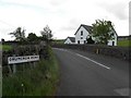
Drumcrow Road
Included in the frame is the former Aughacash National School built in 1828 which is now a dwelling house
Image: © Kenneth Allen
Taken: 2 Jun 2010
0.16 miles
3
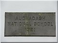
Plaque, Aughacash National School
I am somewhat puzzled about the actual spelling as the letters C and G look similar, on the map the townland is shown as Aughacash, but that could be nothing unusual for spellings to be slightly different
It is located here Image]
Image: © Kenneth Allen
Taken: 2 Jun 2010
0.17 miles
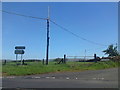
4
Deerpark Road
Heading south towards Aughacash
Image: © Kenneth Allen
Taken: 2 Jun 2010
0.20 miles
5
Deerpark Road
Heading north towards Glenarm
Image: © Kenneth Allen
Taken: 2 Jun 2010
0.20 miles
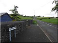
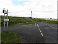
6
Drumcrow Road
Drumcrow Road outside Carnalbanagh where it meets the Deerpark Road.The tattered remains of a flag can be seen on a telegraph pole.
Image: © Paul L
Taken: 7 Jun 2009
0.21 miles