IMAGES TAKEN NEAR TO
Wandsworth Parade, BELFAST, BT4 3FW
Introduction
This page details the photographs taken nearby to Wandsworth Parade, BT4 3FW by members of the Geograph project.
The Geograph project started in 2005 with the aim of publishing, organising and preserving representative images for every square kilometre of Great Britain, Ireland and the Isle of Man.

There are currently over 7.5m images from over14,400 individuals and you can help contribute to the project by visiting https://www.geograph.org.uk
Image Map
Images are licensed for reuse under creativecommons.org/licenses/by-sa/2.0
Notes
- Clicking on the map will re-center to the selected point.
- The higher the marker number, the further away the image location is from the centre of the postcode.
Image Listing (172 Images Found)
Images are licensed for reuse under creativecommons.org/licenses/by-sa/2.0
Image
Details
Distance
1
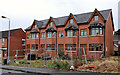
Unfinished houses, Ballyhackamore, Belfast (2011)
An unfinished terrace of four houses in Wandsworth Parade. The “for sale” sign is just visible at middle left in Image (almost two years ago). Continue to Image (June 2013).
Image: © Albert Bridge
Taken: 10 Oct 2011
0.01 miles
2
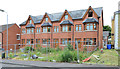
Unfinished houses, Ballyhackamore, Belfast (2013)
See Image (October 2011). Some 20 months later this terrace, at Wandsworth Parade, remains uncompleted. Continue to Image
Image: © Albert Bridge
Taken: 29 Jun 2013
0.01 miles
3
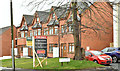
Wandsworth Parade, Belfast (April 2018)
See Image (June 2013). The completed development. The agents’ website shows one remaining unsold. The “for sale” sign refers to Wandsworth Court (right).
I have no connection with the properties and cannot enter into correspondence.
Image: © Albert Bridge
Taken: 2 Apr 2018
0.02 miles
4
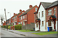
Wandsworth Parade, Belfast (2)
Part of the southern side of Wandsworth Parade, showing the contrast between the recently-built town houses and the older semis with their portholed porches.
Image: © Albert Bridge
Taken: 4 Dec 2009
0.05 miles
5
Greenwood Park, Belfast
The south-facing Greenwood Park looked as if it had the lightest covering of snow in east Belfast.
Image: © Albert Bridge
Taken: 8 Jan 2010
0.05 miles
6
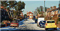
Wandsworth Parade, Belfast
Wandsworth Parade runs from the Belmont Church Road (behind me) towards Campbell Park Avenue. Used only by local traffic, the falling snow was taking hold.
Image: © Albert Bridge
Taken: 3 Dec 2010
0.06 miles
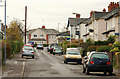
7
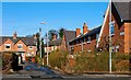
Wandsworth Place, Belfast
Wandsworth Place is a cul-de-sac between the Belmont Church Road and the Wandsworth Road. It was part of a development of some 220 houses built by Belfast Corporation in 1922-24. A masterpiece of planning and design.
Image: © Albert Bridge
Taken: 3 Mar 2008
0.07 miles
8
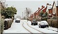
Aston Gardens, Belfast
A snow-covered Aston Gardens seen from the Belmont Church Road. Taken at 09.35 when only a few cars and pedestrians had disturbed the deep snow.
Image: © Albert Bridge
Taken: 17 Dec 2010
0.07 miles
9
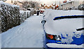
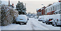
Snow-covered cars, Belfast
Snow-covered cars (and footpath) in Ardgreenan Gardens – very few cars or pedestrians had passed.
Image: © Albert Bridge
Taken: 17 Dec 2010
0.09 miles
10
Wandsworth Gardens, Belfast
The view along Wandsworth Gardens, from the Belmont Road end, towards Campbell Park Avenue Image
Image: © Albert Bridge
Taken: 4 Dec 2009
0.09 miles