IMAGES TAKEN NEAR TO
Hugomont Avenue, BALLYMENA, BT43 6HW
Introduction
This page details the photographs taken nearby to Hugomont Avenue, BT43 6HW by members of the Geograph project.
The Geograph project started in 2005 with the aim of publishing, organising and preserving representative images for every square kilometre of Great Britain, Ireland and the Isle of Man.

There are currently over 7.5m images from over14,400 individuals and you can help contribute to the project by visiting https://www.geograph.org.uk
Image Map
Images are licensed for reuse under creativecommons.org/licenses/by-sa/2.0
Notes
- Clicking on the map will re-center to the selected point.
- The higher the marker number, the further away the image location is from the centre of the postcode.
Image Listing (10 Images Found)
Images are licensed for reuse under creativecommons.org/licenses/by-sa/2.0
Image
Details
Distance
1
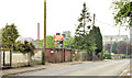
Broughshane Road, Ballymena
View back into Ballymena Town. All Saints' Catholic Church, one of the seven towers of Ballymena can be seen, built in 1860 at the corner of Cushendall Road and Broughshane Road. The tower was completed around the 1900s.
Image: © Lisa Jarvis
Taken: 17 Aug 2007
0.11 miles
2
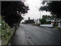
Solar panel, Ballymena
A solar panel powering the flashing lights on a “school” sign, on the Broughshane Road, near Fisherwick Gardens.
Image: © Albert Bridge
Taken: 21 Jun 2013
0.13 miles
3
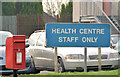
Letter box, Ballymena
Post-mounted EIIR letter box (BT43 25), at the Health Centre and Braid Valley Hospital, on the Cushendall Road.
Image: © Albert Bridge
Taken: 10 Jan 2013
0.13 miles
4
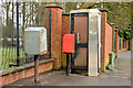
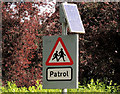
Drop box, letter box and telephone box, Ballymena
A drop box, a post-mounted EIIR letter box (BT43 24) and a telephone box, close to St Patrick’s school, on the Broughshane Road.
Image: © Albert Bridge
Taken: 10 Jan 2013
0.16 miles
5
Development site, Cushendall Road, Ballymena (May 2014)
A large and vacant development site, on the western side of the Cushendall Road, at the corner of Deerfin Way. The agents’ board has a “sold” patch. The Braid Valley Hospital is in the background.
Image: © Albert Bridge
Taken: 20 May 2014
0.16 miles
6
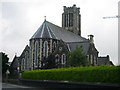
All Saints' Catholic Church, Ballymena
All Saints' Catholic Church, one of the seven towers of Ballymena is at the top of the town, at the corner of Cushendall Road and Broughshane Road. It was built in 1860 and the tower was completed around the 1900s.
Image: © Lisa Jarvis
Taken: 17 Aug 2007
0.18 miles
7
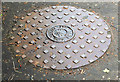
John McNeill manhole cover, Ballymena (1)
A manhole cover, near the roundabout (to the Ecos Centre), on the Broughshane Road. The wet inscription Image was hard to read but it seems to be “John McNeill Ltd” - see Image I might be wrong but I have a notion that this company was part of group insolvency about 35 years ago.
Image: © Albert Bridge
Taken: 21 Jun 2013
0.22 miles
8
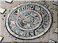
John McNeill manhole cover, Ballymena (2)
See Image The wet (and quite hard to read) inscription “John McNeill Ltd”.
Image: © Albert Bridge
Taken: 21 Jun 2013
0.22 miles
9
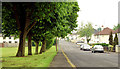
Greenview, Ballymena
Semi-detached houses overlooking a green bordered by mature trees. (Green View on the Google map).
Image: © Albert Bridge
Taken: 20 May 2014
0.24 miles
10
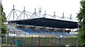
The Showgrounds, Ballymena (1)
See Image (July 2009). The Warden Street stand at The Showgrounds http://en.wikipedia.org/wiki/Ballymena_Showgrounds. See also Image
Image: © Albert Bridge
Taken: 4 Sep 2013
0.25 miles