IMAGES TAKEN NEAR TO
Woodland Park, BALLYMENA, BT42 4PG
Introduction
This page details the photographs taken nearby to Woodland Park, BT42 4PG by members of the Geograph project.
The Geograph project started in 2005 with the aim of publishing, organising and preserving representative images for every square kilometre of Great Britain, Ireland and the Isle of Man.

There are currently over 7.5m images from over14,400 individuals and you can help contribute to the project by visiting https://www.geograph.org.uk
Image Map
Images are licensed for reuse under creativecommons.org/licenses/by-sa/2.0
Notes
- Clicking on the map will re-center to the selected point.
- The higher the marker number, the further away the image location is from the centre of the postcode.
Image Listing (2 Images Found)
Images are licensed for reuse under creativecommons.org/licenses/by-sa/2.0
Image
Details
Distance
1
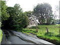
Racavan Road
The gable wall is the only part of this derelict and overgrown building still visible.
Image: © Robert Ashby
Taken: 30 Aug 2017
0.06 miles
2
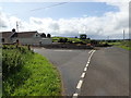
Near Buckna
Junction of Carnalbanagh Rd and Racavan Road.
Image: © Robert Ashby
Taken: 30 Aug 2017
0.18 miles