IMAGES TAKEN NEAR TO
Creevamoy Road, BALLYMENA, BT42 4NW
Introduction
This page details the photographs taken nearby to Creevamoy Road, BT42 4NW by members of the Geograph project.
The Geograph project started in 2005 with the aim of publishing, organising and preserving representative images for every square kilometre of Great Britain, Ireland and the Isle of Man.

There are currently over 7.5m images from over14,400 individuals and you can help contribute to the project by visiting https://www.geograph.org.uk
Image Map
Images are licensed for reuse under creativecommons.org/licenses/by-sa/2.0
Notes
- Clicking on the map will re-center to the selected point.
- The higher the marker number, the further away the image location is from the centre of the postcode.
Image Listing (5 Images Found)
Images are licensed for reuse under creativecommons.org/licenses/by-sa/2.0
Image
Details
Distance
1
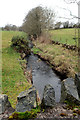
Creevamoy Burn
One many little streams which collect the run-off from the moorland around Slemish. This will flow into the Braid River and eventually to Lough Neahy.
Image: © Robert Ashby
Taken: 7 Dec 2016
0.06 miles
2
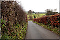
Near Broughshane
Last vestige of autumn colour in the hedgerow on Creeveamoy Road.
Image: © Robert Ashby
Taken: 7 Dec 2016
0.07 miles
3
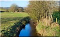
The Creeveamoy Burn near Broughshane
About four miles long, the Creeveamoy Burn flows into the Braid to the east of Broughshane. The view is downstream.
Image: © Albert Bridge
Taken: 3 Jan 2008
0.07 miles
4

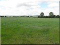
Creevamoy Townland
Looking west towards Great Hill
Image: © Kenneth Allen
Taken: 1 Jul 2010
0.20 miles
5
Creevamoy Townland
Looking north in the direction of Pattersons Hill
Image: © Kenneth Allen
Taken: 1 Jul 2010
0.24 miles