IMAGES TAKEN NEAR TO
Buckna Road, BALLYMENA, BT42 4NR
Introduction
This page details the photographs taken nearby to Buckna Road, BT42 4NR by members of the Geograph project.
The Geograph project started in 2005 with the aim of publishing, organising and preserving representative images for every square kilometre of Great Britain, Ireland and the Isle of Man.

There are currently over 7.5m images from over14,400 individuals and you can help contribute to the project by visiting https://www.geograph.org.uk
Image Map
Images are licensed for reuse under creativecommons.org/licenses/by-sa/2.0
Notes
- Clicking on the map will re-center to the selected point.
- The higher the marker number, the further away the image location is from the centre of the postcode.
Image Listing (4 Images Found)
Images are licensed for reuse under creativecommons.org/licenses/by-sa/2.0
Image
Details
Distance
1

Near Buckna
St Patrick may well have been familiar with a scene something like this. He reputedly spent his youth as a slave tending sheep on the slopes of Slemish, the eroded remains of a volcano active about 60 million years ago.
Image: © Robert Ashby
Taken: 24 Jan 2016
0.07 miles
2
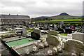
Near Buckna
A more appropriate setting for a cemetery would be hard to find, nestling in the shadow of Slemish, the eroded remains of a 60 million year old volcano, where St Patrick was reputed to have spent his youth as a slave tending sheep.
Image: © Robert Ashby
Taken: 24 Jan 2016
0.10 miles
3
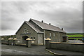
Buckna Church Hall
On the Buckna Road near the village.
Image: © Robert Ashby
Taken: 24 Jan 2016
0.13 miles
4
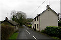
Approaching Buckna
The village is just down the road to the left.
Image: © Robert Ashby
Taken: 24 Jan 2016
0.25 miles