IMAGES TAKEN NEAR TO
Guide Street, BALLYMENA, BT42 4JU
Introduction
This page details the photographs taken nearby to Guide Street, BT42 4JU by members of the Geograph project.
The Geograph project started in 2005 with the aim of publishing, organising and preserving representative images for every square kilometre of Great Britain, Ireland and the Isle of Man.

There are currently over 7.5m images from over14,400 individuals and you can help contribute to the project by visiting https://www.geograph.org.uk
Image Map
Images are licensed for reuse under creativecommons.org/licenses/by-sa/2.0
Notes
- Clicking on the map will re-center to the selected point.
- The higher the marker number, the further away the image location is from the centre of the postcode.
Image Listing (86 Images Found)
Images are licensed for reuse under creativecommons.org/licenses/by-sa/2.0
Image
Details
Distance
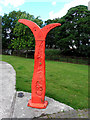
1
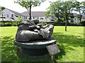
A big hand, Broughshane
Carved out of solid wood, it is pictured at Little Acre Wood beside Houston's Mill
See close-up of plaque here Image]
Image: © Kenneth Allen
Taken: 1 Jul 2010
0.01 miles
2
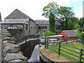
Houston's Mill, Broughshane
Houston’s Mill was an old Flax/Corn Mill with a history dating back to the early days of the Irish linen industry. mote at http://www.discovernorthernireland.com/Houstons-Mill-Broughshane-Ballymena-P14359
Image: © Kenneth Allen
Taken: 1 Jul 2010
0.01 miles
3
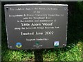
Plaque, Little Acorn Wood
It is located here Image]
Image: © Kenneth Allen
Taken: 1 Jul 2010
0.02 miles
4
Bygone items, Houston's Mill (3)
Pictured here Image]
Image: © Kenneth Allen
Taken: 1 Jul 2010
0.02 miles
5
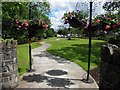
Little Acorn Wood, Broughshane
Looking east from the entrance along Main Street
Image: © Kenneth Allen
Taken: 1 Jul 2010
0.02 miles
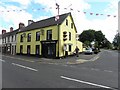
6
The Thatch Inn, Broughshane (1)
A thatched bar, in the main street, which seems to have existed in 1773 – if not earlier. Once known as the “O’Neill Arms”. See also Image
Image: © Albert Bridge
Taken: 12 Sep 2009
0.03 miles
7
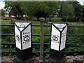
Sustrans signpost, Broughshane
Pictured in Little Acre Wood, beside Houston'e Mill
Image: © Kenneth Allen
Taken: 1 Jul 2010
0.03 miles
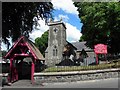
8
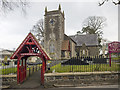
St Patrick's parish church, Broughshane
Church of Ireland parish church on the Rathkeel Road, Broughshane. It was built in 1765 by Charles O’Neill of Shane’s Castle, later enlarged in 1829 and again in 1859. The lych gate dates from 1882. See other images at http://www.geograph.org.uk/of/patricks%20broughshane%20church .
Image: © Rossographer
Taken: 3 Mar 2018
0.04 miles
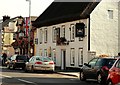
9
The Slemish Tavern, Broughshane
It is located at the junction of Rathkeel Road and Main Street
Image: © Kenneth Allen
Taken: 1 Jul 2010
0.04 miles
10
St Patrick's Church of Ireland, Broughshane
It is located along Rathkeel Road. It is in the Diocese of Connor and the Parish of Skerry, Rathcavan and Newtowncrommelin
Image: © Kenneth Allen
Taken: 1 Jul 2010
0.04 miles