IMAGES TAKEN NEAR TO
Wardlow Crescent, BALLYMENA, BT42 4HN
Introduction
This page details the photographs taken nearby to Wardlow Crescent, BT42 4HN by members of the Geograph project.
The Geograph project started in 2005 with the aim of publishing, organising and preserving representative images for every square kilometre of Great Britain, Ireland and the Isle of Man.

There are currently over 7.5m images from over14,400 individuals and you can help contribute to the project by visiting https://www.geograph.org.uk
Image Map
Images are licensed for reuse under creativecommons.org/licenses/by-sa/2.0
Notes
- Clicking on the map will re-center to the selected point.
- The higher the marker number, the further away the image location is from the centre of the postcode.
Image Listing (4 Images Found)
Images are licensed for reuse under creativecommons.org/licenses/by-sa/2.0
Image
Details
Distance
1
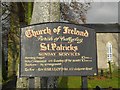
Notice board, St Patrick's Church
It is located here Image]
Image: © Kenneth Allen
Taken: 23 Nov 2010
0.14 miles
2
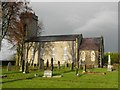
St Patrick's Church of Ireland, Ballmarlagh
Pictured along the A36 Moorfields Road, to the east of Ballymena, it is in the Parish of Ballyclug
See close-up of notice board here Image]
Image: © Kenneth Allen
Taken: 23 Nov 2010
0.15 miles
3
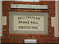
Plaque, Ballymarlow Orange Hall
It is located here Image]
Image: © Kenneth Allen
Taken: 23 Nov 2010
0.19 miles
4
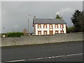
Ballymarlow Orange Hall, Ballymarlagh
It is located along the A36, to the east of Ballymena
Built in 1886, see close-up of plaque here Image]
Image: © Kenneth Allen
Taken: 23 Nov 2010
0.23 miles