IMAGES TAKEN NEAR TO
James Street, BALLYMENA, BT42 4DE
Introduction
This page details the photographs taken nearby to James Street, BT42 4DE by members of the Geograph project.
The Geograph project started in 2005 with the aim of publishing, organising and preserving representative images for every square kilometre of Great Britain, Ireland and the Isle of Man.

There are currently over 7.5m images from over14,400 individuals and you can help contribute to the project by visiting https://www.geograph.org.uk
Image Map
Images are licensed for reuse under creativecommons.org/licenses/by-sa/2.0
Notes
- Clicking on the map will re-center to the selected point.
- The higher the marker number, the further away the image location is from the centre of the postcode.
Image Listing (52 Images Found)
Images are licensed for reuse under creativecommons.org/licenses/by-sa/2.0
Image
Details
Distance
1
Kanes grating cover, Ballymena
A grating cover, at Henry Street (Larne Street on the Google map), with the inscription “Kane Brothers Iron Founders Ballymena”. For two other covers from the same foundry, to a different design, see Image and Image
Image: © Albert Bridge
Taken: 17 May 2013
0.06 miles
2
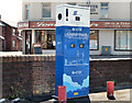
E-car charge point, Ballymena
An E-car charging point at the Henry Street (Larne Street on the Google map)/Gilmore Street car park.
Image: © Albert Bridge
Taken: 17 May 2013
0.08 miles
3

Pillar box, Ballymena
EIIR pillar box (number not visible) at Henry Street (Larne Street on the Google map).
Image: © Albert Bridge
Taken: 2 Aug 2012
0.10 miles
4
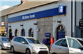
The Ulster Bank (Harryville branch), Ballymena
See Image The Harryville branch (Henry Street – Larne Street on the Google map) of the Ulster Bank is due to close on 21 June 2013 with accounts transferred to Wellington Street.
Image: © Albert Bridge
Taken: 17 May 2013
0.11 miles
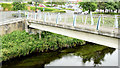
5
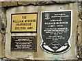
The William McNinch footbridge plaques, Ballymena
See Image Three self-explanatory plaques at the Edward Street end of the bridge.
Image: © Albert Bridge
Taken: 13 Jun 2014
0.11 miles
6
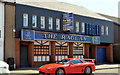
"The Raglan", Ballymena
The former bar at 20-24 Queen Street now advertised for sale. The agents’ brochure includes the following description “This subject development opportunity benefits from Full Planning Consent (Ref: G/2007/1153/F) for: Change of use from public lounge bar to ground floor retail units and first floor office unit . . . . LETTING AGREEMENTS ALSO CONSIDERED”. This photograph appears as a matter of record only. I have no connection with any of the parties involved in the sale.
Image: © Albert Bridge
Taken: 17 May 2013
0.11 miles
7
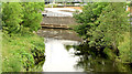
The Braid, Ballymena - June 2014(2)
The wooded banks of the Braid, looking downstream from the McNinch Bridge Image The retail park is visible at the top.
Image: © Albert Bridge
Taken: 13 Jun 2014
0.11 miles
8
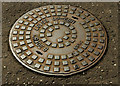
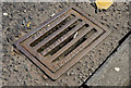
Manhole cover, Ballymena
A manhole cover in Queen Street. No foundry name but the inscription reads “MB2-60 BS497 GRADE B 24 D 89”.
Image: © Albert Bridge
Taken: 2 Aug 2012
0.12 miles
9
The William McNinch footbridge, Ballymena
A footbridge, across the Braid, erected to replace one built in 1957. It now connects Harryville to the Braidwater Retail Park. Edward Street is behind me. The original bridge (before this part of Ballymena was developed) should be visible in this Facebook link https://www.facebook.com/Oldphotosballymena/photos/a.396081643848007.1073741837.254410138015159/313962352059937/?type=1. Image provides more information.
Image: © Albert Bridge
Taken: 13 Jun 2014
0.12 miles