IMAGES TAKEN NEAR TO
Moat Road, BALLYMENA, BT42 4DA
Introduction
This page details the photographs taken nearby to Moat Road, BT42 4DA by members of the Geograph project.
The Geograph project started in 2005 with the aim of publishing, organising and preserving representative images for every square kilometre of Great Britain, Ireland and the Isle of Man.

There are currently over 7.5m images from over14,400 individuals and you can help contribute to the project by visiting https://www.geograph.org.uk
Image Map
Images are licensed for reuse under creativecommons.org/licenses/by-sa/2.0
Notes
- Clicking on the map will re-center to the selected point.
- The higher the marker number, the further away the image location is from the centre of the postcode.
Image Listing (25 Images Found)
Images are licensed for reuse under creativecommons.org/licenses/by-sa/2.0
Image
Details
Distance
1
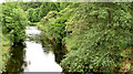
The Braid, Ballymena - June 2014(1)
The wooded banks of the Braid, looking upstream from the McNinch Bridge Image The dual carriageway and the Braidwater Retail Park are hidden, out of picture to the left.
Image: © Albert Bridge
Taken: 13 Jun 2014
0.04 miles
2
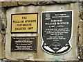
The William McNinch footbridge plaques, Ballymena
See Image Three self-explanatory plaques at the Edward Street end of the bridge.
Image: © Albert Bridge
Taken: 13 Jun 2014
0.05 miles
3
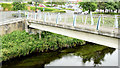
The William McNinch footbridge, Ballymena
A footbridge, across the Braid, erected to replace one built in 1957. It now connects Harryville to the Braidwater Retail Park. Edward Street is behind me. The original bridge (before this part of Ballymena was developed) should be visible in this Facebook link https://www.facebook.com/Oldphotosballymena/photos/a.396081643848007.1073741837.254410138015159/313962352059937/?type=1. Image provides more information.
Image: © Albert Bridge
Taken: 13 Jun 2014
0.06 miles
4
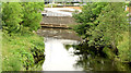
The Braid, Ballymena - June 2014(2)
The wooded banks of the Braid, looking downstream from the McNinch Bridge Image The retail park is visible at the top.
Image: © Albert Bridge
Taken: 13 Jun 2014
0.07 miles
5
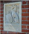
Gate panel. King George's Field, Ballymena (1)
One of two reliefs on the gateposts at the King George’s Fields on the Larne Road. For a short history of the scheme and photographs of other examples see the shared description below.
Image: © Albert Bridge
Taken: 17 May 2013
0.12 miles
6
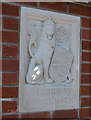
Gate panel, King George's Field, Ballymena (2)
One of two reliefs on the gateposts at the King George’s Fields on the Larne Road. For a short history of the scheme and photographs of other examples see the shared description below.
Image: © Albert Bridge
Taken: 17 May 2013
0.12 miles
7
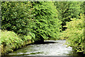
The Braid, Ballymena - June 2014(4)
The straight course of the Braid, immediately downstream from this weir Image The Google map makes the river look much wider than it really is.
Image: © Albert Bridge
Taken: 13 Jun 2014
0.12 miles
8
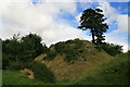
Harryville Motte
The remains of a 12th century Norman motte and bailey, built on a prominent site overlooking the River Braid, and located beside a housing estate on the southern outskirts of Ballymena.
Image: © Lisa Jarvis
Taken: 15 Aug 2007
0.13 miles
9
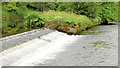
Weir, Ballymena (June 2014)
The weir, on the Braid, between the Ballykeel and Harryville Bridges. The present course (right) has the appearance of an artificial diversion to provide power for the now-closed and demolished Braidwater Mill Image
Image: © Albert Bridge
Taken: 13 Jun 2014
0.14 miles
10
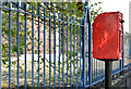
Letter box, Harryville, Ballymena (2)
Post-mounted EIIR letter box (BT42 119), on the Larne Road, close to Wakehurst Park.
Image: © Albert Bridge
Taken: 17 May 2013
0.16 miles