IMAGES TAKEN NEAR TO
Barnish Road, BALLYMENA, BT42 3NZ
Introduction
This page details the photographs taken nearby to Barnish Road, BT42 3NZ by members of the Geograph project.
The Geograph project started in 2005 with the aim of publishing, organising and preserving representative images for every square kilometre of Great Britain, Ireland and the Isle of Man.

There are currently over 7.5m images from over14,400 individuals and you can help contribute to the project by visiting https://www.geograph.org.uk
Image Map
Images are licensed for reuse under creativecommons.org/licenses/by-sa/2.0
Notes
- Clicking on the map will re-center to the selected point.
- The higher the marker number, the further away the image location is from the centre of the postcode.
Image Listing (4 Images Found)
Images are licensed for reuse under creativecommons.org/licenses/by-sa/2.0
Image
Details
Distance
1
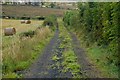
Lane near Tardree forest
This lane runs off the Barnish Road. Tardree forest is out of sight to the left.
Image: © Albert Bridge
Taken: 15 Sep 2007
0.09 miles
2
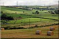
Mid-Antrim countryside
This scene near Tardree forest, on the Barnish Road, is typical of this part of Co Antrim. Elliott’s Hill windfarm Image is on the horizon at top left.
Image: © Albert Bridge
Taken: 15 Sep 2007
0.09 miles
3
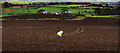
A bucolic mystery
A spare hi-viz jacket makes a servicable scarecrow in this newly ploughed field beside the Barnish Road close to Tardree. I was intrigued by the way the tracks of, presumably, a quad bike lead up to the scarecrow and then just vanish, leaving no trace of a return journey. Elementary, my dear Watson?
Image: © Robert Ashby
Taken: 29 Dec 2013
0.12 miles
4
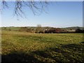
Near Tardee Mountain
Looking north-east from the Tardee Road
Image: © Kenneth Allen
Taken: 13 Nov 2009
0.24 miles