IMAGES TAKEN NEAR TO
Fernisky Court, BALLYMENA, BT42 3LN
Introduction
This page details the photographs taken nearby to Fernisky Court, BT42 3LN by members of the Geograph project.
The Geograph project started in 2005 with the aim of publishing, organising and preserving representative images for every square kilometre of Great Britain, Ireland and the Isle of Man.

There are currently over 7.5m images from over14,400 individuals and you can help contribute to the project by visiting https://www.geograph.org.uk
Image Map
Images are licensed for reuse under creativecommons.org/licenses/by-sa/2.0
Notes
- Clicking on the map will re-center to the selected point.
- The higher the marker number, the further away the image location is from the centre of the postcode.
Image Listing (26 Images Found)
Images are licensed for reuse under creativecommons.org/licenses/by-sa/2.0
Image
Details
Distance
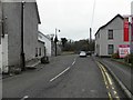
1
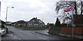
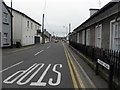
Junction in Kells
The Fernisky road branches off Steeple road to the south of the village.
Image: © Jonathan Billinger
Taken: 13 Nov 2007
0.15 miles
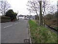
2
Fernisky Road
Heading north towards Main Street, Kells
Image: © Kenneth Allen
Taken: 21 Mar 2011
0.16 miles
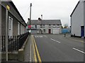
3
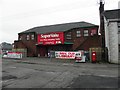
Business units, Kells
Located beside Supervalu are a Takeaway, Hair-dressing Salon and a Nursery Group.
Image: © Kenneth Allen
Taken: 21 Mar 2011
0.16 miles
4
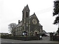
Kells Presbyterian Church
It is located along Church Road
Image: © Kenneth Allen
Taken: 21 Mar 2011
0.16 miles
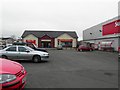
6
Supervalu, Kells
It is located at Main Street
Image: © Kenneth Allen
Taken: 21 Mar 2011
0.17 miles
7
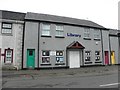
Library, Kells
It is located at Main Street
Image: © Kenneth Allen
Taken: 21 Mar 2011
0.17 miles
8
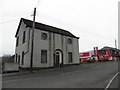
Masonic Hall, Kells
It is located along Church Road
Image: © Kenneth Allen
Taken: 21 Mar 2011
0.18 miles
10
Church Road, Kells
Looking north-west
Image: © Kenneth Allen
Taken: 21 Mar 2011
0.19 miles