IMAGES TAKEN NEAR TO
Moorfields Road, BALLYMENA, BT42 3HQ
Introduction
This page details the photographs taken nearby to Moorfields Road, BT42 3HQ by members of the Geograph project.
The Geograph project started in 2005 with the aim of publishing, organising and preserving representative images for every square kilometre of Great Britain, Ireland and the Isle of Man.

There are currently over 7.5m images from over14,400 individuals and you can help contribute to the project by visiting https://www.geograph.org.uk
Image Map
Images are licensed for reuse under creativecommons.org/licenses/by-sa/2.0
Notes
- Clicking on the map will re-center to the selected point.
- The higher the marker number, the further away the image location is from the centre of the postcode.
Image Listing (19 Images Found)
Images are licensed for reuse under creativecommons.org/licenses/by-sa/2.0
Image
Details
Distance
1
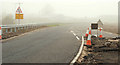
New dual carriageway, Ballymena (14)
See Image The Liminary Road, a minor road which ran to the existing Ballee Road East, has been realigned to avoid an “at grade” crossing of the new road. It now comes in at the Larne Road roundabout instead.
Image: © Albert Bridge
Taken: 28 Nov 2009
0.11 miles
2
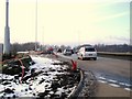
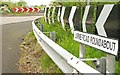
Larne Road Roundabout, Ballymena (Dec 09)
See Image and http://www.wesleyjohnston.com/roads/a26-m2link.html for details on the A26/M2 link works that are underway in this shot.
Taken from the Liminary Road exit.
Image: © Dean Molyneaux
Taken: 28 Dec 2009
0.14 miles
3
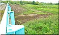
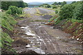
New dual carriageway, Ballymena (2)
See Image The view across the southern side of the roundabout. The new road will fill the space in the middle. The brown patch at top left is where vegetation was removed before the 2009 nesting season to avoid disturbing the birds. The southbound on-slip will pass (approximately) across the top of the photo. Continue to Image
Image: © Albert Bridge
Taken: 27 May 2009
0.15 miles
4
New dual carriageway, Ballymena (7)
See Image The southbound on-slip will be behind the red and white chevrons at top left. Red and white chevrons are used to indicate a temporary diversion – this one has been temporary for 40 years! Continue to Image
Image: © Albert Bridge
Taken: 27 May 2009
0.16 miles
5
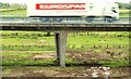
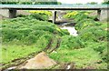
M2, Ballymena - the missing link
When the M2 Ballymena bypass opened in 1969 the intention was to connect it to the Belfast-Antrim section. In the event the plan was abandoned and a dual carriageway was (eventually) built instead over most of the route. This still left a gap at the southern end (seen here). The plan to make a direct connection to the Belfast road has been revived - see Image For comparison “then and now” see Image
Image: © Albert Bridge
Taken: 23 Jun 2006
0.18 miles
6
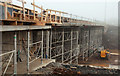
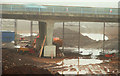
New dual carriageway, Ballymena (13)
See Image Strengthening work on the southern side of the flyover on the northern side of the Larne Road roundabout (looking towards the Larne direction). The new road will occupy the lower right part of the site. Continue to Image
Image: © Albert Bridge
Taken: 28 Nov 2009
0.20 miles
7
New dual carriageway, Ballymena (5)
See Image Looking south from the northern side of the Larne Road roundabout. The new road will occupy the all of the land in between. Continue to Image For comparison “then and now” see Image
Image: © Albert Bridge
Taken: 27 May 2009
0.20 miles
8
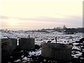
Snow on the M2 link site, Ballymena (Dec 09)
Snow covers the site south of the Larne Road Roundabout.
See Image and http://www.wesleyjohnston.com/roads/a26-m2link.html
This is part of plans to link up the M2 Ballymena Bypass at Jct. 10 with the A26.
Image: © Dean Molyneaux
Taken: 28 Dec 2009
0.21 miles
9
New dual carriageway, Ballymena (4)
See Image Looking north from the southern side of the Larne Road roundabout. The new road will occupy the most of the land in between. Continue to Image For comparison “then and now” see Image
Image: © Albert Bridge
Taken: 27 May 2009
0.21 miles
10
New dual carriageway, Ballymena (11)
See Image Working underway strengthening the flyover on the southern side of the Larne Road roundabout. Continue to Image
Image: © Albert Bridge
Taken: 28 Nov 2009
0.21 miles