IMAGES TAKEN NEAR TO
Scottstown Road, BALLYMENA, BT42 3EB
Introduction
This page details the photographs taken nearby to Scottstown Road, BT42 3EB by members of the Geograph project.
The Geograph project started in 2005 with the aim of publishing, organising and preserving representative images for every square kilometre of Great Britain, Ireland and the Isle of Man.

There are currently over 7.5m images from over14,400 individuals and you can help contribute to the project by visiting https://www.geograph.org.uk
Image Map
Images are licensed for reuse under creativecommons.org/licenses/by-sa/2.0
Notes
- Clicking on the map will re-center to the selected point.
- The higher the marker number, the further away the image location is from the centre of the postcode.
Image Listing (3 Images Found)
Images are licensed for reuse under creativecommons.org/licenses/by-sa/2.0
Image
Details
Distance
1
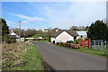
Scotstown Road
A little hamlet of dwellings on this quiet lane.
Image: © Robert Ashby
Taken: 8 Apr 2015
0.10 miles
2
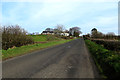
Kilgad Road
Looking east-northeast on the Kilgad Road at Moorfields.
Image: © Robert Ashby
Taken: 8 Apr 2015
0.20 miles
3
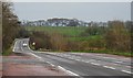
The Moorfields Road near Ballymena
The Moorfields Road is part of the Ballymena – Larne Road. This is the view towards Larne at the staggered crossroads with the Scottstown Road. In another mile or so the road begins its ascent, through moorland, towards Shane’s Hill Image
Image: © Albert Bridge
Taken: 21 Nov 2007
0.25 miles