IMAGES TAKEN NEAR TO
Wakehurst Industrial Estate, Wakehurst Road, BALLYMENA, BT42 3AZ
Introduction
This page details the photographs taken nearby to Wakehurst Industrial Estate, Wakehurst Road, BT42 3AZ by members of the Geograph project.
The Geograph project started in 2005 with the aim of publishing, organising and preserving representative images for every square kilometre of Great Britain, Ireland and the Isle of Man.

There are currently over 7.5m images from over14,400 individuals and you can help contribute to the project by visiting https://www.geograph.org.uk
Image Map
Images are licensed for reuse under creativecommons.org/licenses/by-sa/2.0
Notes
- Clicking on the map will re-center to the selected point.
- The higher the marker number, the further away the image location is from the centre of the postcode.
Image Listing (10 Images Found)
Images are licensed for reuse under creativecommons.org/licenses/by-sa/2.0
Image
Details
Distance
1
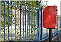
Letter box, Harryville, Ballymena (2)
Post-mounted EIIR letter box (BT42 119), on the Larne Road, close to Wakehurst Park.
Image: © Albert Bridge
Taken: 17 May 2013
0.12 miles
2
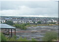
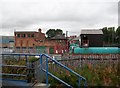
Derelict land behind Queen Street, Ballymena
Image: © Colin Pyle
Taken: 30 Jul 2022
0.12 miles
3
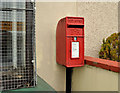
Letter box, Harryville, Ballymena
Post-mounted EIIR letter box (BT42 111), at Queen Street, near Paradise Avenue, opposite the remains of the old railway goods yard.
Image: © Albert Bridge
Taken: 10 Jan 2013
0.12 miles
4
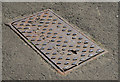
Ulster Foundries air valve cover, Ballymena
An Ulster Foundries http://www.geograph.org.uk/search.php?i=41571529 air valve cover, on the Larne Road, close to the Wakehurst Road mini roundabout.
Image: © Albert Bridge
Taken: 17 May 2013
0.14 miles
5
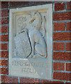
Gate panel. King George's Field, Ballymena (1)
One of two reliefs on the gateposts at the King George’s Fields on the Larne Road. For a short history of the scheme and photographs of other examples see the shared description below.
Image: © Albert Bridge
Taken: 17 May 2013
0.14 miles
6
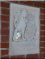
Gate panel, King George's Field, Ballymena (2)
One of two reliefs on the gateposts at the King George’s Fields on the Larne Road. For a short history of the scheme and photographs of other examples see the shared description below.
Image: © Albert Bridge
Taken: 17 May 2013
0.14 miles
7
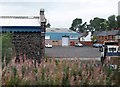
Industrial estate off Railway Street, Ballymena
Image: © Eric Jones
Taken: 23 Sep 2013
0.18 miles
8
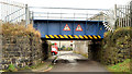
Railway bridge, Ballymena (5)
A bridge carrying the Belfast (right) – Londonderry/Portrush railway across Ladysmith Terrace Image Queen Street is in the background. This one is quite low having a height restriction of 7ft/2.15 metres.
Image: © Albert Bridge
Taken: 10 Jan 2013
0.21 miles
9
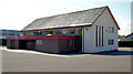
Harryville gospel hall, Ballymena
A gospel hall on the Larne Road, built (I think but I might be wrong) in the early 1970’s.
Image: © Albert Bridge
Taken: 17 May 2013
0.22 miles
10
Industrial buildings between Railway Street and the Belfast/Coleraine railway line
Image: © Eric Jones
Taken: 23 Sep 2013
0.22 miles