IMAGES TAKEN NEAR TO
Braidwater Retail Park, Larne Road Link, BALLYMENA, BT42 3AG
Introduction
This page details the photographs taken nearby to Braidwater Retail Park, Larne Road Link, BT42 3AG by members of the Geograph project.
The Geograph project started in 2005 with the aim of publishing, organising and preserving representative images for every square kilometre of Great Britain, Ireland and the Isle of Man.

There are currently over 7.5m images from over14,400 individuals and you can help contribute to the project by visiting https://www.geograph.org.uk
Image Map
Images are licensed for reuse under creativecommons.org/licenses/by-sa/2.0
Notes
- Clicking on the map will re-center to the selected point.
- The higher the marker number, the further away the image location is from the centre of the postcode.
Image Listing (66 Images Found)
Images are licensed for reuse under creativecommons.org/licenses/by-sa/2.0
Image
Details
Distance
1
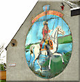
King William mural, Ballymena (2013)
See Image (August 2007). The same mural, at the corner of Bridge Street and North Street, in 2013. This photograph appears as a matter of record only and does not express any political or sectarian opinion. Image shows it in 1982.
Image: © Albert Bridge
Taken: 10 Jan 2013
0.07 miles
2
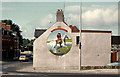
King William mural, Ballymena (1982)
See Image The same mural, at the corner of Bridge Street and North Street, in 1982. This photograph appears as a matter of record only and does not express any political or sectarian opinion.
Image: © Albert Bridge
Taken: 14 Aug 1982
0.07 miles
3
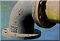
Old pipe, Ballymena (2)
See Image The inscription showing that it’s kitemarked and made to British Standard 2035. The figures “23101970” seem to be the date of casting – 23 October 1970.
Image: © Albert Bridge
Taken: 17 May 2013
0.08 miles
4
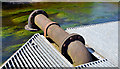
Old pipe, Ballymena (1)
An old cast-iron pipe, just upstream from here Image behind the shops. Whether disused or in use and what its past or present purpose was or is I know not. Image shows the inscription with the date of manufacture but not the name of the foundry.
Image: © Albert Bridge
Taken: 17 May 2013
0.08 miles
5
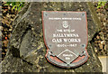
Gas works plaque, Ballymena
A plaque, opposite here Image, marking the site of the old gas works https://www.facebook.com/Oldphotosballymena/photos/a.335399769916195.1073741831.254410138015159/295549703901202/?type=1.
Image: © Albert Bridge
Taken: 13 Jun 2014
0.08 miles
8
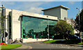
"The Braid", Ballymena
“The Braid” opened in 2008. A new building, designed by the Consarc Design Group, grafted onto the former Town Hall Image (just visible behind the trees on the right), it “weaves together history, arts and culture alongside contemporary conference, tourism and civic facilities”.
Image: © Albert Bridge
Taken: 2 Aug 2012
0.09 miles
9
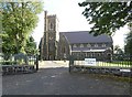
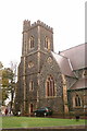
St Patrick's Church of Ireland
Ballymena Parish Church was consecrated in 1855. It was totally destroyed by a fire in 1879 but rebuilt along the same lines and re-opened in 1881. It is famed for having the only peel of twelve bells in Northern Ireland. For more details see the church website: http://www.stpatricksballymena.co.uk/
Image: © Gerald England
Taken: 13 Sep 2020
0.09 miles
10
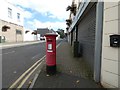
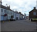
Castle Street
Looking up Castle Street towards St Patrick's Church. The George VI postbox BT43 6 in the foreground is a "Priority Postbox".
Image: © Gerald England
Taken: 13 Sep 2020
0.10 miles