IMAGES TAKEN NEAR TO
Rathcavan Drive, BALLYMENA, BT42 2QH
Introduction
This page details the photographs taken nearby to Rathcavan Drive, BT42 2QH by members of the Geograph project.
The Geograph project started in 2005 with the aim of publishing, organising and preserving representative images for every square kilometre of Great Britain, Ireland and the Isle of Man.

There are currently over 7.5m images from over14,400 individuals and you can help contribute to the project by visiting https://www.geograph.org.uk
Image Map
Images are licensed for reuse under creativecommons.org/licenses/by-sa/2.0
Notes
- Clicking on the map will re-center to the selected point.
- The higher the marker number, the further away the image location is from the centre of the postcode.
Image Listing (3 Images Found)
Images are licensed for reuse under creativecommons.org/licenses/by-sa/2.0
Image
Details
Distance
1
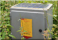
Traffic counter, Ballymena
A Roads Service solar-powered traffic counter, almost hidden by nettles, beside the Galgorm Road, on the town side of Dan’s Road.
Image: © Albert Bridge
Taken: 1 Jul 2013
0.17 miles
2
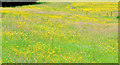
Buttercups, Ballymena (2013-1)
Part of a magnificent display of buttercups in a field between the Galgorm Road (behind me) and the Old Galgorm Road. Image shows the view from the Old Galgorm Road.
Image: © Albert Bridge
Taken: 1 Jul 2013
0.18 miles
3
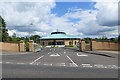
Sourhill Road
Wellington Presbyterian Church in Galgorm.
Image: © Robert Ashby
Taken: 29 Jun 2014
0.24 miles