IMAGES TAKEN NEAR TO
Nursery View, BALLYMENA, BT42 2QE
Introduction
This page details the photographs taken nearby to Nursery View, BT42 2QE by members of the Geograph project.
The Geograph project started in 2005 with the aim of publishing, organising and preserving representative images for every square kilometre of Great Britain, Ireland and the Isle of Man.

There are currently over 7.5m images from over14,400 individuals and you can help contribute to the project by visiting https://www.geograph.org.uk
Image Map
Images are licensed for reuse under creativecommons.org/licenses/by-sa/2.0
Notes
- Clicking on the map will re-center to the selected point.
- The higher the marker number, the further away the image location is from the centre of the postcode.
Image Listing (2 Images Found)
Images are licensed for reuse under creativecommons.org/licenses/by-sa/2.0
Image
Details
Distance
1
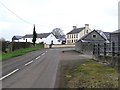
Road at Killybegs
It is located near Clarkestown
Image: © Kenneth Allen
Taken: 18 Dec 2007
0.17 miles
2
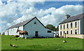
On the Nursery Road
An exploratory cycle ride along an unfamiliar road led me to this bucolic scene near Clarkestown complete with free-range ducks and geese and a magnificent draft horse (Clydesdale?). A rare enough sight in itself, no doubt it would help plough a furrow or two at agricultural shows from time to time.
Image: © Robert Ashby
Taken: 4 Aug 2013
0.18 miles