IMAGES TAKEN NEAR TO
Slaght Road, BALLYMENA, BT42 2JJ
Introduction
This page details the photographs taken nearby to Slaght Road, BT42 2JJ by members of the Geograph project.
The Geograph project started in 2005 with the aim of publishing, organising and preserving representative images for every square kilometre of Great Britain, Ireland and the Isle of Man.

There are currently over 7.5m images from over14,400 individuals and you can help contribute to the project by visiting https://www.geograph.org.uk
Image Map
Images are licensed for reuse under creativecommons.org/licenses/by-sa/2.0
Notes
- Clicking on the map will re-center to the selected point.
- The higher the marker number, the further away the image location is from the centre of the postcode.
Image Listing (3 Images Found)
Images are licensed for reuse under creativecommons.org/licenses/by-sa/2.0
Image
Details
Distance
1
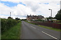
Slaght Road near Ballymena
The rear-facing row of brick houses ahead is called Hazelwood Terrace and is much older than the neighbouring modern bungalows and houses. They look like they might have been mill-workers homes or similar at some time in the past.
Image: © Robert Ashby
Taken: 29 Jun 2014
0.11 miles
2
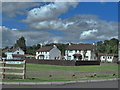
Carmossan Park
A small housing estate beside the Slaght Road near Ballymena.
Image: © Robert Ashby
Taken: 4 Aug 2013
0.20 miles
3
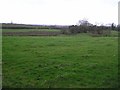
Appletee Townland
Looking west in the direction of Clarkestown
Image: © Kenneth Allen
Taken: 25 Jan 2008
0.20 miles