IMAGES TAKEN NEAR TO
Tullygarley Far, BALLYMENA, BT42 2HW
Introduction
This page details the photographs taken nearby to Tullygarley Far, BT42 2HW by members of the Geograph project.
The Geograph project started in 2005 with the aim of publishing, organising and preserving representative images for every square kilometre of Great Britain, Ireland and the Isle of Man.

There are currently over 7.5m images from over14,400 individuals and you can help contribute to the project by visiting https://www.geograph.org.uk
Image Map
Images are licensed for reuse under creativecommons.org/licenses/by-sa/2.0
Notes
- Clicking on the map will re-center to the selected point.
- The higher the marker number, the further away the image location is from the centre of the postcode.
Image Listing (3 Images Found)
Images are licensed for reuse under creativecommons.org/licenses/by-sa/2.0
Image
Details
Distance
1
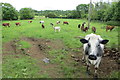
Tullygarley Near townland
An inquisitive cow - though in fact I think it's maybe a de-horned bull - regards me with interest, or perhaps suspicion, from its field in Tullygarley. As a townie, from this angle it's hard to tell!
Image: © Robert Ashby
Taken: 29 Jun 2014
0.12 miles
2
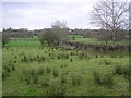
Tullaghgarley Near
Looking to the east.
Image: © Kenneth Allen
Taken: 25 Jan 2008
0.20 miles
3
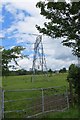
Tullygarley Far townland
A shorter than usual pylon at Tullygarley. This type is generally used to carry wires under another set where power lines intersect and from the angle of the wires the pylons at either side seemed to be normal sized. There wasn't an intersection that I could see and there didn't seem to be any reason to lower it at this point. Perhaps another one is planned to cross here in the future.
Image: © Robert Ashby
Taken: 29 Jun 2014
0.22 miles