IMAGES TAKEN NEAR TO
Phoenix Fields, BALLYMENA, BT42 2EZ
Introduction
This page details the photographs taken nearby to Phoenix Fields, BT42 2EZ by members of the Geograph project.
The Geograph project started in 2005 with the aim of publishing, organising and preserving representative images for every square kilometre of Great Britain, Ireland and the Isle of Man.

There are currently over 7.5m images from over14,400 individuals and you can help contribute to the project by visiting https://www.geograph.org.uk
Image Map
Images are licensed for reuse under creativecommons.org/licenses/by-sa/2.0
Notes
- Clicking on the map will re-center to the selected point.
- The higher the marker number, the further away the image location is from the centre of the postcode.
Image Listing (28 Images Found)
Images are licensed for reuse under creativecommons.org/licenses/by-sa/2.0
Image
Details
Distance
1
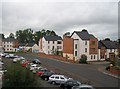
Houses and apartments in Railway Street, Ballymena
Image: © Eric Jones
Taken: 23 Sep 2013
0.06 miles
2
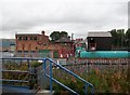
Industrial buildings between Railway Street and the Belfast/Coleraine railway line
Image: © Eric Jones
Taken: 23 Sep 2013
0.09 miles
3
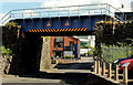
Railway bridge, Ballymena (3)
The bridge carrying the Belfast (right) – Londonderry railway across Railway Street.
Image: © Albert Bridge
Taken: 2 Aug 2012
0.09 miles
4
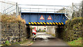
Railway bridge, Ballymena (5)
A bridge carrying the Belfast (right) – Londonderry/Portrush railway across Ladysmith Terrace Image Queen Street is in the background. This one is quite low having a height restriction of 7ft/2.15 metres.
Image: © Albert Bridge
Taken: 10 Jan 2013
0.10 miles
5
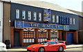
"The Raglan", Ballymena
The former bar at 20-24 Queen Street now advertised for sale. The agents’ brochure includes the following description “This subject development opportunity benefits from Full Planning Consent (Ref: G/2007/1153/F) for: Change of use from public lounge bar to ground floor retail units and first floor office unit . . . . LETTING AGREEMENTS ALSO CONSIDERED”. This photograph appears as a matter of record only. I have no connection with any of the parties involved in the sale.
Image: © Albert Bridge
Taken: 17 May 2013
0.12 miles
7
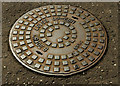
Manhole cover, Ballymena
A manhole cover in Queen Street. No foundry name but the inscription reads “MB2-60 BS497 GRADE B 24 D 89”.
Image: © Albert Bridge
Taken: 2 Aug 2012
0.13 miles
8
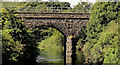
Railway bridge, Ballymena (2)
The stone bridge carrying the Belfast (left) – Londonderry railway across the Braid Image Not (from what I can see) listed.
Image: © Albert Bridge
Taken: 2 Aug 2012
0.13 miles
9
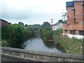
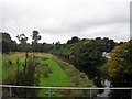
The River Braid downstream of Bridge Street
The railway bridge can be seen in the distance.
Image: © Eric Jones
Taken: 9 Aug 2011
0.14 miles
10

Pillar box, Ballymena
EIIR pillar box (number not visible) at Henry Street (Larne Street on the Google map).
Image: © Albert Bridge
Taken: 2 Aug 2012
0.14 miles