IMAGES TAKEN NEAR TO
Tobar Park, BALLYMENA, BT42 1NN
Introduction
This page details the photographs taken nearby to Tobar Park, BT42 1NN by members of the Geograph project.
The Geograph project started in 2005 with the aim of publishing, organising and preserving representative images for every square kilometre of Great Britain, Ireland and the Isle of Man.

There are currently over 7.5m images from over14,400 individuals and you can help contribute to the project by visiting https://www.geograph.org.uk
Image Map
Images are licensed for reuse under creativecommons.org/licenses/by-sa/2.0
Notes
- Clicking on the map will re-center to the selected point.
- The higher the marker number, the further away the image location is from the centre of the postcode.
Image Listing (5 Images Found)
Images are licensed for reuse under creativecommons.org/licenses/by-sa/2.0
Image
Details
Distance
1
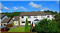
Approaching Cullybackey
Houses backing on to the railway.
Image: © Robert Ashby
Taken: 18 Sep 2015
0.12 miles
2
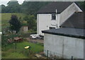
Last house on Markstown Close, seen from a train
Image: © Colin Pyle
Taken: 30 Jul 2022
0.13 miles
3
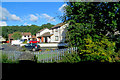
Approaching Cullybackey
Houses in Markstown Close seen from the train.
Image: © Robert Ashby
Taken: 18 Sep 2015
0.16 miles
4
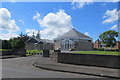
Methodist Church
Cullybackey Methodist Church on the Shellinghill Road.
Image: © Robert Ashby
Taken: 5 Jun 2014
0.24 miles
5
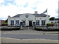
Buick Memorial School, Cullybackey
Pictured along Ballymena Road
See close-up of clock here Image]
Image: © Kenneth Allen
Taken: 15 Jun 2016
0.25 miles