IMAGES TAKEN NEAR TO
Cardonaghy Road, BALLYMENA, BT42 1JE
Introduction
This page details the photographs taken nearby to Cardonaghy Road, BT42 1JE by members of the Geograph project.
The Geograph project started in 2005 with the aim of publishing, organising and preserving representative images for every square kilometre of Great Britain, Ireland and the Isle of Man.

There are currently over 7.5m images from over14,400 individuals and you can help contribute to the project by visiting https://www.geograph.org.uk
Image Map
Images are licensed for reuse under creativecommons.org/licenses/by-sa/2.0
Notes
- Clicking on the map will re-center to the selected point.
- The higher the marker number, the further away the image location is from the centre of the postcode.
Image Listing (5 Images Found)
Images are licensed for reuse under creativecommons.org/licenses/by-sa/2.0
Image
Details
Distance
1
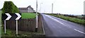
Road at Ahoghill
Heading north-west out of the village
Image: © Kenneth Allen
Taken: 1 Jan 2008
0.09 miles
2
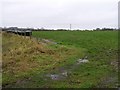
Countryside north of Ahoghill
Looking westwards
Image: © Kenneth Allen
Taken: 1 Jan 2008
0.12 miles
3
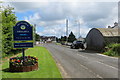
In Ahoghill
Ahoghill, a name which some visitors have difficulty getting their tongues round, means Ford of the Yew Tree and is an award winning village the sign tells us. It's difficult to translate the pronunciation in written form as it involves a sort of throat-clearing noise on the "gh" syllable.
Image: © Robert Ashby
Taken: 14 Jun 2014
0.20 miles
4
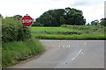
Road junction
Junction of Lisnafillon Road and Cardonaghy Road.
Image: © Robert Ashby
Taken: 29 Jun 2014
0.22 miles
5
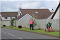
Gardener at work
Another new tree for the neatly kept verge beside the Glenhugh Road in Ahoghill. The planter to the right is some sort of ex-farm implement. Perhaps someone can identify what it was used for. To my untutored eye it looks like a big mincing machine.
Image: © Robert Ashby
Taken: 14 Jun 2014
0.23 miles