IMAGES TAKEN NEAR TO
Maine Grove, BALLYMENA, BT42 1HF
Introduction
This page details the photographs taken nearby to Maine Grove, BT42 1HF by members of the Geograph project.
The Geograph project started in 2005 with the aim of publishing, organising and preserving representative images for every square kilometre of Great Britain, Ireland and the Isle of Man.

There are currently over 7.5m images from over14,400 individuals and you can help contribute to the project by visiting https://www.geograph.org.uk
Image Map
Images are licensed for reuse under creativecommons.org/licenses/by-sa/2.0
Notes
- Clicking on the map will re-center to the selected point.
- The higher the marker number, the further away the image location is from the centre of the postcode.
Image Listing (14 Images Found)
Images are licensed for reuse under creativecommons.org/licenses/by-sa/2.0
Image
Details
Distance
1
Old railway milepost, Cullybackey
See Image The original 36¼ milepost, on the down side of the single line at Cullybackey North level crossing.
Image: © Albert Bridge
Taken: 11 Apr 2014
0.14 miles
2
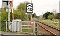
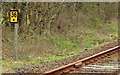
Level crossing warning sign, Cullybackey
The sign, at Cullybackey North level crossing, reminding drivers about the level crossing and speed restriction at Cullybackey station.
Image: © Albert Bridge
Taken: 11 Apr 2014
0.14 miles
3
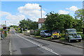
Ballymena Road
A selection of vehicles of varying types and vintages on display beside the level crossing on the Ballymena Road Cullybackey.
Image: © Robert Ashby
Taken: 5 Jun 2014
0.14 miles
4
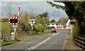
Cullybackey North level crossing (April 2014)
Cullybackey North level crossing looking, along the Old Cullybackey Road, towards Cullybackey.
Image: © Albert Bridge
Taken: 11 Apr 2014
0.14 miles
5
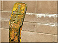
Railway milepost, Cullybackey (1)
Milepost 36¼, on the up side of the single line, close to the Ballymena side of Cullybackey North level crossing. Mileposts are usually on the down side. Their original purpose was to calculate charges in the days when railways were common carriers (ie legally obliged to accept all goods offered). Now they serve to advise drivers of operation matters such as “contractor working between mileposts XX and XX¼”. Image shows the original cast version on the other side of the line.
Image: © Albert Bridge
Taken: 11 Apr 2014
0.14 miles
6
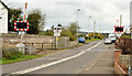
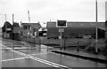
Cullybackey South level crossing (April 2014)
Cullybackey South level crossing looking, along the Ballymena Road, towards Cullybackey.
Image: © Albert Bridge
Taken: 11 Apr 2014
0.16 miles
7
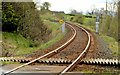
Railway, Cullybackey - April 2014(1)
The Londonderry-Belfast railway, looking towards Ballymena and Belfast, at Cullybackey South level crossing. The line here, laid with jointed flat-bottom rails, is subject to a 70mph restriction.
Image: © Albert Bridge
Taken: 11 Apr 2014
0.18 miles
8
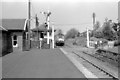
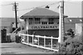
88 passing Cullybackey Signal Box
88 passing Cullybackey signal box with a non stop Londonderry to Belfast Central service.
Image: © Wilson Adams
Taken: 10 Jun 1979
0.18 miles
10
Site of Cullybackey Signal Box
17 years on from the previous photo of Cullybackey Signal Box.
The signal box has been demolished, and the crossing is now an automatic half barrier type, the building to the right is the former goods shed.
Image: © Wilson Adams
Taken: 3 Jan 1996
0.18 miles