IMAGES TAKEN NEAR TO
Maine Avenue, BALLYMENA, BT42 1FQ
Introduction
This page details the photographs taken nearby to Maine Avenue, BT42 1FQ by members of the Geograph project.
The Geograph project started in 2005 with the aim of publishing, organising and preserving representative images for every square kilometre of Great Britain, Ireland and the Isle of Man.

There are currently over 7.5m images from over14,400 individuals and you can help contribute to the project by visiting https://www.geograph.org.uk
Image Map
Images are licensed for reuse under creativecommons.org/licenses/by-sa/2.0
Notes
- Clicking on the map will re-center to the selected point.
- The higher the marker number, the further away the image location is from the centre of the postcode.
Image Listing (10 Images Found)
Images are licensed for reuse under creativecommons.org/licenses/by-sa/2.0
Image
Details
Distance
1
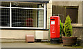
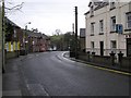
Pillar box BT42 74, Cullybackey
EIIR pillar box (BT42 74) at Main Street (Ballymena Road on the Google map), close to Pottinger Street.
Image: © Albert Bridge
Taken: 11 Apr 2014
0.06 miles
2

School clock, Cullybackey
The clock on the Buick Memorial Primary School, Main Street (Ballymena Road on the Google map). The following is a quotation from the website of the Cullybackey and District Historical Society: “A new Public Elementary School was erected on the Main Street in 1900 to replace the “Auld School at the Pun” under the management of the Rev George Raphael Buick. It was renamed the “Buick Memorial Public Elementary School” after Dr Buick’s death in 1904 as he had given all of his money towards the building of the school. It was rebuilt and enlarged in 1937 by the Ballymena Education Committee”.
Image: © Albert Bridge
Taken: 11 Apr 2014
0.11 miles
3
Buick Memorial School, Cullybackey
Pictured along Ballymena Road
See close-up of clock here Image]
Image: © Kenneth Allen
Taken: 15 Jun 2016
0.11 miles
4
The Royal British Legion, Cullybackey
Pictured along Ballymena Road
Image: © Kenneth Allen
Taken: 15 Jun 2016
0.13 miles
5
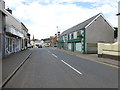
Ballymena Road, Cullybackey
Heading WNW
Image: © Kenneth Allen
Taken: 15 Jun 2016
0.16 miles
6
Cullybackey, County Antrim
Looking west
Image: © Kenneth Allen
Taken: 1 Jan 2008
0.20 miles
7
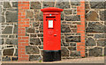
Pillar box BT42 151, Cullybackey (1)
EIIR pillar box (BT42 151) at the “Eurospar” at the corner of Old Mill Park and Main Street (Ballymena Road on the Google map) (out of picture to the right). Image shows the box in its setting.
Image: © Albert Bridge
Taken: 11 Apr 2014
0.23 miles
8
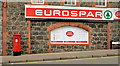
Pillar box BT42 151, Cullybackey (2)
See Image The same box, in its setting, at the “Eurospar”/post office at the corner of Old Mill Park and Main Street (Ballymena Road on the Google map) (out of picture to the right).
Image: © Albert Bridge
Taken: 11 Apr 2014
0.23 miles
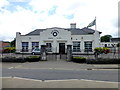
9
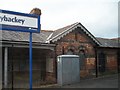
Cullybackey Station
This station is on the Ballymena-Coleraine line, about 3 miles north of Ballymena. With a population of some 2,500, Cullybackey is a predominantly Ulster-Scots town.
Image: © Eric Jones
Taken: 23 Sep 2013
0.25 miles
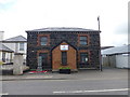
10
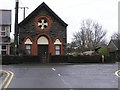
Cullybackey Masonic Hall
It is located near the centre of the village
Image: © Kenneth Allen
Taken: 1 Jan 2008
0.25 miles