
IMAGES TAKEN NEAR TO
Oval Court, BELFAST, BT4 1FZ
Introduction
This page details the photographs taken nearby to Oval Court, BT4 1FZ by members of the Geograph project.
The Geograph project started in 2005 with the aim of publishing, organising and preserving representative images for every square kilometre of Great Britain, Ireland and the Isle of Man.

There are currently over 7.5m images from over14,400 individuals and you can help contribute to the project by visiting https://www.geograph.org.uk
Image Map
Images are licensed for reuse under creativecommons.org/licenses/by-sa/2.0
Notes
- Clicking on the map will re-center to the selected point.
- The higher the marker number, the further away the image location is from the centre of the postcode.
Image Listing (464 Images Found)
Images are licensed for reuse under creativecommons.org/licenses/by-sa/2.0
Image
Details
Distance
1
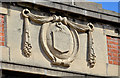
Former Mersey Street primary school, Belfast (2)
See Image The Belfast coat of arms above what was once the school’s front entrance. Continue to Image
Image: © Albert Bridge
Taken: 21 Apr 2013
0.04 miles
2
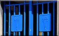
Former Mersey Street primary school, Belfast (3)
See Image Ironwork, on what was once the school’s front entrance, depicting the “torch of learning” – familiar to an earlier generation from the pre-Worboys “school” sign http://www.sabre-roads.org.uk/wiki/index.php?title=File:P1010188.JPG.
Image: © Albert Bridge
Taken: 21 Apr 2013
0.04 miles
3
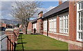
Former Mersey Street primary school, Belfast (1)
Mersey Street Primary School was completed in 1923 to a design by R S Wilshere. It closed in 2006. After a period on the “at risk” register it was restored and re-opened in 2011 as housing association apartments. See also Image for the coat of arms and Image for ironwork detail.
Image: © Albert Bridge
Taken: 21 Apr 2013
0.04 miles
4
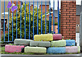
Multi-coloured tyres, Belfast (April 2016)
Painted tyres, used as flower beds, at the side of St Christopher's Church of Ireland, Mersey Street Image
Image: © Albert Bridge
Taken: 4 Apr 2016
0.05 miles
5
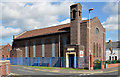
St Christopher's (CoI), Mersey Street, Belfast
St Christopher’s Church of Ireland was built in 1931 to what might have been a joint design by RH Gibson and Henry Seaver. The brick is an unusual colour.
Image: © Albert Bridge
Taken: 2 Sep 2013
0.06 miles
6
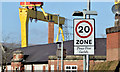
20 mph zone, Mersey Street, Belfast (February 2015)
Mersey Street is subject to a 20 mph speed limit between Parkgate Crescent (here) and Dee Street.
Image: © Albert Bridge
Taken: 19 Feb 2015
0.07 miles
7
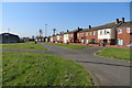
Comber Greenway
Bloomfield Walkway at the start of the Comber Greenway, an 8 mile traffic-free walking and cycling path.
Image: © Robert Ashby
Taken: 22 Apr 2015
0.08 miles
8
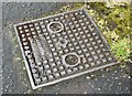
Forsythe access cover, Belfast - May 2015(1)
See Image (September 2010). Another Forsythe (of Gt George’s Street) access cover. This one is at Tamar Street. Image shows the inscription.
Image: © Albert Bridge
Taken: 28 May 2015
0.09 miles
9

Forsythe access cover, Belfast - May 2015(2)
See Image The inscription “J Forsythe Ltd Gt Georges St Belfast”.
Image: © Albert Bridge
Taken: 28 May 2015
0.09 miles
10
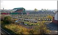
Vacant land, east Belfast
See Image The streets around Dee Street have seen considerable redevelopment in recent years. This area, between the Sydenham bypass Image and Mersey Street, has been cleared pending rebuilding. The street pattern remains with Harkness Parade on the left. The Oval football ground is in the background (left).
Image: © Albert Bridge
Taken: 24 Oct 2007
0.09 miles