
IMAGES TAKEN NEAR TO
Derwent Street, BELFAST, BT4 1DZ
Introduction
This page details the photographs taken nearby to Derwent Street, BT4 1DZ by members of the Geograph project.
The Geograph project started in 2005 with the aim of publishing, organising and preserving representative images for every square kilometre of Great Britain, Ireland and the Isle of Man.

There are currently over 7.5m images from over14,400 individuals and you can help contribute to the project by visiting https://www.geograph.org.uk
Image Map
Images are licensed for reuse under creativecommons.org/licenses/by-sa/2.0
Notes
- Clicking on the map will re-center to the selected point.
- The higher the marker number, the further away the image location is from the centre of the postcode.
Image Listing (196 Images Found)
Images are licensed for reuse under creativecommons.org/licenses/by-sa/2.0
Image
Details
Distance
1

Dee St crossing
This is one of three new "Puffin" crossings recently installed on the Comber Greenway. These new-style crossings have a movement-sensitive sensor to detect when cyclists and pedestrians are on the crossing and only when the sensor detects that the crossing is clear do the lights change in favour of the traffic. This has the advantage that slower, elderly pedestrian users aren't caught part-way across when the lights changed on the usual timed basis and also traffic won't be held up unnecessarily by having to wait for a period after the crossing is clear when only faster users, i.e cyclists, are crossing.
Image: © Robert Ashby
Taken: 10 Mar 2012
0.08 miles
2

No 74 Dee Street, Belfast (April 2016)
A vacant shop with upstairs flat, at the corner of Dee Street and Tern Street. Currently offered for sale and described by the agents as “. . . . this landmark building at 74 Dee Street on the corner of Tern Street which has been owner occupied and trading as "Shaws [sic] Newsagents" for approximately 30 years and two generations. Over time the property has been converted to provide two separate units and a two bed, two reception duplex apartment offering good investment potential and perhaps even an opportuinity [sic] for further development subject to approvals. Would suit owner occupier and invester [sic] alike.”
This photograph appears as a matter of record only. I have no connection with any of the parties involved in the sale. I cannot enter into correspondence.
Image: © Albert Bridge
Taken: 4 Apr 2016
0.08 miles
3
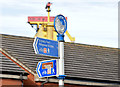
National Cycle Network sign, Ballymacarrett, Belfast (February 2015)
National Cycle Network route 99 signs at the Dee Street end of the Ballymacarrett Walkway Image Previously seen in January 2011 Image
Image: © Albert Bridge
Taken: 19 Feb 2015
0.09 miles
4
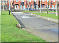
The Ballymacarrett Walkway, Belfast (February 2015)
The former route of the Belfast and County Down Railway, looking towards Dee Street, now a footpath and part of National Cycle Network route 99. It continues towards Dundonald and Comber as the Comber Greenway Image and Image Image (January 2011) shows the view in the opposite direction.
Image: © Albert Bridge
Taken: 19 Feb 2015
0.09 miles
5
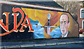
"Narnia" mural, Belfast (1)
Part of a mural, on a bend, at the Dee Street end of Pansy Street, based on “The Chronicles of Narnia” http://en.wikipedia.org/wiki/The_Chronicles_of_Narnia by the locally-born writer CS Lewis. Image shows another part of the same mural.
Image: © Albert Bridge
Taken: 10 Nov 2013
0.09 miles
6
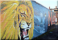
"Narnia" mural, Belfast (2)
See Image Another part of the same mural.
Image: © Albert Bridge
Taken: 10 Nov 2013
0.11 miles
7
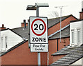
20 mph sign, Severn Street, Belfast (April 2016)
A 20 mph speed limit sign at the Dee Street end of Severn Street – another of the inner-city 20mph zones.
Image: © Albert Bridge
Taken: 4 Apr 2016
0.11 miles
8
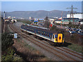
Train approaching site of Ballymacarrett Halt - 2003
A Northern Ireland Railways' 80-class set is approaching the site of Ballymacarrett Halt (see: Image] ) with the 09.44 passenger service from Great Victoria Street station to Bangor. The white bridge in the left background is the rebuilt Sydenham Fly-Over, near which point the railway line to Newcastle (closed 1950) left the Belfast - Bangor line (see: Image] ).
Image: © The Carlisle Kid
Taken: 31 Mar 2003
0.12 miles
9
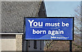
Biblical message, Belfast (February 2015)
A quotation from John 3:7 at Calvary Baptist church, Dee Street.
Image: © Albert Bridge
Taken: 19 Feb 2015
0.13 miles
10
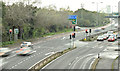
The Sydenham bypass, Dee Street, Belfast - November 2015(1)
The traffic-light controlled “T” junction with Dee Street and the entrance to Belfast Harbour estate. If the envisaged widening ever takes place it would be replaced by a reconstructed bridge at Dee Street and, at some more distant time, a new grade-separated junction at the Connsbank Road Image
Image: © Albert Bridge
Taken: 4 Nov 2015
0.13 miles