IMAGES TAKEN NEAR TO
Oriel Road, ANTRIM, BT41 4HP

Introduction

This page details the photographs taken nearby to Oriel Road, BT41 4HP by members of the Geograph project.

The Geograph project started in 2005 with the aim of publishing, organising and preserving representative images for every square kilometre of Great Britain, Ireland and the Isle of Man.

There are currently over 7.5m images from over14,400 individuals and you can help contribute to the project by visiting https://www.geograph.org.uk

Image Map


Images are licensed for reuse under creativecommons.org/licenses/by-sa/2.0
Notes
  • Clicking on the map will re-center to the selected point.
  • The higher the marker number, the further away the image location is from the centre of the postcode.

Image Listing (22 Images Found)

Images are licensed for reuse under creativecommons.org/licenses/by-sa/2.0
  • ...
Image
Details
Distance
1
The Oriel Road, Antrim
Mainly residential road running from the Dublin Road towards Antrim Railway Station.
Image: © Rossographer Taken: 28 Jun 2011
0.05 miles
2
St Comgall?s Church, Castle Street, Antrim
This is one of two Catholic Churches in the Parish of Antrim. The parish was formed from the recent amalgamation of St Congall's and St Joseph's parishes. http://www.antrimparish.com/
Image: © Eric Jones Taken: 16 Jun 2013
0.10 miles
3
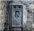
Flush Bracket, Antrim
Flush bracket bench mark located on the front wall of St Comgalls Parish Church, Antrim Image The number on the bracket is OSBM 3233. The mark has been levelled to 22.81 metres above MSL. A flush bracket is a type of bench mark set onto the face of a building. See also http://www.geograph.org.uk/search.php?i=11037856 for many other examples I have found.
Image: © Rossographer Taken: 28 Jun 2011
0.10 miles
4
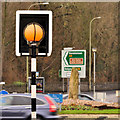
"Belisha" beacon, Antrim
A "Belisha" beacon, with sighting board, at this Zebra crossing Image on the Oriel Road.
Image: © Albert Bridge Taken: 27 Dec 2011
0.11 miles
5
Zebra crossing, Antrim
A zebra crossing at the end of the Oriel Road. The Dublin Road is on the left, the Randalstown Road ahead and the Ballymena Road to the right.
Image: © Albert Bridge Taken: 27 Dec 2011
0.11 miles
6
Letter box, Antrim
Post-mounted EIIR letter box on the Randalstown Road. The Ballymena Road is in the background.
Image: © Albert Bridge Taken: 27 Dec 2011
0.15 miles
7
Fungus, Antrim (2)
See Image Under deciduous trees, in the Castle Gardens, close to the Round Pond Image Continue to Image
Image: © Albert Bridge Taken: 30 Aug 2008
0.17 miles
8
Weed-spraying train, Antrim
The CIE weed-spraying train, hauled by 169S, approaching the Steeple Road bridge, Antrim. The line was subsequently singled.
Image: © Albert Bridge Taken: 6 Jun 1985
0.18 miles
9
The Castle Gardens, Antrim (3)
See Image The Round Pond http://www.antrim.gov.uk/index.cfm/website_Key/27/Category_key/129/Page_Key/467/show/more (with imitation crannog) at the northern end of the gardens.
Image: © Albert Bridge Taken: 30 Aug 2008
0.19 miles
10
Antrim's PSNI Station, Dublin Road, Antrim
Image: © Eric Jones Taken: 16 Jun 2013
0.21 miles
  • ...