
IMAGES TAKEN NEAR TO
Gloverstown Road, ANTRIM, BT41 3PH
Introduction
This page details the photographs taken nearby to Gloverstown Road, BT41 3PH by members of the Geograph project.
The Geograph project started in 2005 with the aim of publishing, organising and preserving representative images for every square kilometre of Great Britain, Ireland and the Isle of Man.

There are currently over 7.5m images from over14,400 individuals and you can help contribute to the project by visiting https://www.geograph.org.uk
Image Map
Images are licensed for reuse under creativecommons.org/licenses/by-sa/2.0
Notes
- Clicking on the map will re-center to the selected point.
- The higher the marker number, the further away the image location is from the centre of the postcode.
Image Listing (3 Images Found)
Images are licensed for reuse under creativecommons.org/licenses/by-sa/2.0
Image
Details
Distance
1
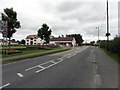
B18, Main Street, Toome
Heading ESE; in the distance is the local Spar Shop
Image: © Kenneth Allen
Taken: 25 Sep 2010
0.18 miles
2
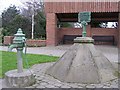
John Cary Fountain, Toome
The inscription on the top reads, "This fountain free to all". The design and gift of John Cary, 1860 who lead a chequered past, starting off as a minister of the church and later accused of attempted murder, but also attributed as a public benefactor. His name also appears at Duneane Primary school. His grave behind Duneane Presbyterian Church is appropriately eccentric.
Image: © Kenneth Allen
Taken: 13 Feb 2007
0.18 miles
3
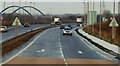
New Randalstown - Castledawson road (8)
See Image The existing Toome bypass seen from the Drumderg roundabout Image When the road is completed, this view will be obstructed by the flyover. Continue to Image
Image: © Albert Bridge
Taken: 18 Dec 2009
0.24 miles