IMAGES TAKEN NEAR TO
Browns Bay Drive, LARNE, BT40 3RU
Introduction
This page details the photographs taken nearby to Browns Bay Drive, BT40 3RU by members of the Geograph project.
The Geograph project started in 2005 with the aim of publishing, organising and preserving representative images for every square kilometre of Great Britain, Ireland and the Isle of Man.

There are currently over 7.5m images from over14,400 individuals and you can help contribute to the project by visiting https://www.geograph.org.uk
Image Map
Images are licensed for reuse under creativecommons.org/licenses/by-sa/2.0
Notes
- Clicking on the map will re-center to the selected point.
- The higher the marker number, the further away the image location is from the centre of the postcode.
Image Listing (23 Images Found)
Images are licensed for reuse under creativecommons.org/licenses/by-sa/2.0
Image
Details
Distance
1
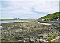
Brown's Bay
On the northern coast of Islandmagee.
Image: © Mike Faherty
Taken: 25 Jun 2018
0.01 miles
2
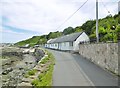
Brown's Bay, cottages
Former coastguard cottages on Brown's Bay Drive.
Image: © Mike Faherty
Taken: 25 Jun 2018
0.01 miles
3
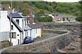
Near Brown's Bay, Islandmagee
The coast between Brown's Bay and Ferris Bay (often called "Ferris's Bay") includes a few houses in a cul-de-sac overlooking the North Channel. It is one of several bays in northern Islandmagee. The local name is "English's
Port" which is not shown on the OS map. Image shows a (later) view in the opposite direction.
Image: © Albert Bridge
Taken: 21 May 2006
0.04 miles
4
Brown's Bay, jetty
At Port Narrow; originally for coastguard use.
Image: © Mike Faherty
Taken: 25 Jun 2018
0.07 miles
5
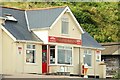
The Brown's Bay Stores, Islandmagee
Confectionery/convenience shop, with very limited opening hours, overlooking Brown’s Bay Image
Image: © Albert Bridge
Taken: 28 Jul 2009
0.07 miles
6
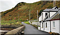
Brown's Bay Drive, Islandmagee
See Image Brown’s Bay Drive (otherwise “English’s Port”) looking, in the opposite direction, towards the bracken-covered hillside on the Ferris Bay Road.
Image: © Albert Bridge
Taken: 21 Oct 2011
0.07 miles
7
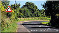
The Ferris Bay Road, Islandmagee (4)
At the top of the hill from Ballylumford, the Ferris Bay Road makes a sharp turn to the right before dropping down towards Brown’s Bay Image
Image: © Albert Bridge
Taken: 30 Aug 2010
0.08 miles
8
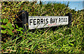
Ferris Bay Road sign, Islandmagee
The sign at the bend in the Ferris Bay Road Image The road is often called the “Ferris’s Bay Road”.
Image: © Albert Bridge
Taken: 30 Aug 2010
0.08 miles
9
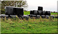
Silage, Islandmagee
Silage bales beside the Ferris Bay Road Image
Image: © Albert Bridge
Taken: 21 Oct 2011
0.09 miles
10
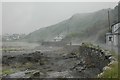
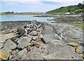
Sea Wall, English's Bay, Islandmagee
On a hot, yet soaking wet, day, mist rises from the foreshore and road in English's Bay
Image: © Robin Somes
Taken: 12 Jun 2007
0.09 miles