IMAGES TAKEN NEAR TO
Ferris Bay Road, LARNE, BT40 3RT
Introduction
This page details the photographs taken nearby to Ferris Bay Road, BT40 3RT by members of the Geograph project.
The Geograph project started in 2005 with the aim of publishing, organising and preserving representative images for every square kilometre of Great Britain, Ireland and the Isle of Man.

There are currently over 7.5m images from over14,400 individuals and you can help contribute to the project by visiting https://www.geograph.org.uk
Image Map
Images are licensed for reuse under creativecommons.org/licenses/by-sa/2.0
Notes
- Clicking on the map will re-center to the selected point.
- The higher the marker number, the further away the image location is from the centre of the postcode.
Image Listing (23 Images Found)
Images are licensed for reuse under creativecommons.org/licenses/by-sa/2.0
Image
Details
Distance
1
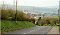
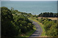
The Ferris Bay Road, Islandmagee (2)
See Image Further to the north east, the same road, from near the entrance to the Golf Club, looking towards Ballylumford.
Image: © Albert Bridge
Taken: 22 Apr 2010
0.07 miles
2

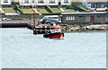
Larne lifeboat at Ballylumford
See Image The “Dr John” visiting Ballylumford harbour on a crew-training exercise.
Image: © Albert Bridge
Taken: 6 May 2001
0.09 miles
3
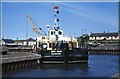
Dredging Ballylumford harbour
The “Bar Maid” dredging at Ballylumford harbour. She was owned by the Coleraine Harbour Commissioners but undertook outside contract work when required.
Image: © Albert Bridge
Taken: 26 May 1989
0.09 miles
4
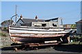
Old Boat
This old boat at Ballylumford Harbour is in a sorry state. It could do with some T.L.C., before she's fit to be launched again.
Image: © Wilson Adams
Taken: 1 Apr 2007
0.09 miles
5
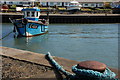
The "Golden Fleece" at Ballylumford
The lobster boat “Golden Fleece” at her moorings at Ballylumford harbour. The grid lines on the “Multimap” and the paper OS map do not coincide exactly here so I have opted for the Multimap version for this and previous photos.
Image: © Albert Bridge
Taken: 5 Apr 2007
0.09 miles
6
The Ballylumford Road, Islandmagee (1)
The Ballylumford Road runs from the western end of the Hollow Road at Carnspindle to the Brown’s Bay Road. In doing so it passes the back of Ballylumford power station and drops dramatically thereafter. This is the view from near the top of the hill with the entrance to Larne Lough in the background.
Image: © Albert Bridge
Taken: 13 Aug 2006
0.09 miles
7

A trawler at Ballylumford
The small harbour at Ballylumford is used mainly by pleasure craft and the ferry to and from Larne. It was quite a surprise to see the small trawler “Bread Winner”. The only fishing boat normally using the harbour is a potter. She had sought shelter at Larne during inclement weather and had had to move to Ballylumford because of other shipping movements in the lough.
Image: © Albert Bridge
Taken: 8 Oct 2006
0.09 miles
8

The "Volando" at Ballylumford
The small harbour at Ballylumford sees mainly pleasure craft and the ferry to and from Larne. The “Volando” is probably the biggest pleasure boat to have used the harbour in recent years.
Image: © Albert Bridge
Taken: 10 Sep 2006
0.09 miles
9
Islandmagee Ferry Boat
John Mc Loughlin's ferry boat, "ADRIENNE" brings passengers from Ballylumford to Larne Harbour.
Image: © Wilson Adams
Taken: 18 Apr 2003
0.09 miles
10
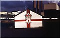
A Painted Shed
A painted gable of a wooden shed at Ballylumford Harbour displaying the emblem of Northern Ireland. The three tall chimneys and building in the background is, Ballylumford Power Station.
Image: © Wilson Adams
Taken: 21 Sep 1980
0.09 miles