1
Weed-spraying train near Magheramorne
The CIE weed-spraying train, hauled by 169S, running along the causeway on the Glynn side of Magheramorne, on the return trip to Belfast. The number “169SA” is still showing on this side. The railway is not shown on the Google map.
Image: © Albert Bridge
Taken: 6 Jun 1985
0.05 miles
2
Shore Road, entrance to Magheramorne House
Image: © David Dixon
Taken: 29 Sep 2017
0.06 miles
3
Sealink set at Magheramorne
Northern Ireland Railway's Sealink liveried 70-class set approaches Magheramorne station with the 14.00 passenger service from Larne Harbour to Belfast (York Road). Painted in these colours to publicise BR's Larne - Stranraer "Sealink" ferry service, the set was withdrawn in October 1985 and dumped in the bottom of a water-filled quarry due to the presence of blue asbestos.
Image: © The Carlisle Kid
Taken: 29 Jun 1985
0.11 miles
4
Railway causeway, Magheramorne
See
Image There is also a causeway on the Glynn side of Magheramorne station
Image where the line passes between the Shore Road and Larne Lough. The train is the 15.20 Belfast York Road – Larne Town. The railway is not shown on the Google map – see the satellite photograph instead.
Image: © Albert Bridge
Taken: 2 Apr 1988
0.13 miles
5
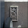
Flush Bracket, Magheramorne
Ordnance survey flush bracket bench mark on the western end of a gable wall at Newpark off the Shore Road between Magheramorne and Glynn.
The number on the bracket is OSBM 3399.
The mark has been levelled to 3.99 metres above MSL.
Image: © Rossographer
Taken: 18 Feb 2023
0.17 miles
6
The Shore Road, Magheramorne
The A2 Shore Road at Magheramorne.
Image: © Rossographer
Taken: 18 Feb 2023
0.18 miles
7
Letter box, Magheramorne
Post-mounted EIIR letter box (BT40 639), at Newpark, on the Shore Road.
Image: © Albert Bridge
Taken: 30 Apr 2012
0.20 miles
8
Telephone box, Magheramorne
A telephone box at Newpark, on the Shore Road, close to
Image
Image: © Albert Bridge
Taken: 30 Apr 2012
0.21 miles
9
A2, Shore Road, near Magheramorne
Magheramorne (from the Irish: Machaire Morna) is a small hamlet in County Antrim. It is about 5 miles south of Larne on the shores of Larne Lough.
Image: © David Dixon
Taken: 28 Sep 2017
0.22 miles
10
The Ballypollard Road near Magheramorne
The Ballypollard Road runs to the south west of Magheramorne before making a steep descent towards the Shore Road between Magheramorne and Glynn (sometimes “the Glynn”). This is the road just after it has started its fall towards the main road.
Image: © Albert Bridge
Taken: 16 Dec 2006
0.23 miles


