IMAGES TAKEN NEAR TO
Inverary Heights, LARNE, BT40 3BL
Introduction
This page details the photographs taken nearby to Inverary Heights, BT40 3BL by members of the Geograph project.
The Geograph project started in 2005 with the aim of publishing, organising and preserving representative images for every square kilometre of Great Britain, Ireland and the Isle of Man.

There are currently over 7.5m images from over14,400 individuals and you can help contribute to the project by visiting https://www.geograph.org.uk
Image Map
Images are licensed for reuse under creativecommons.org/licenses/by-sa/2.0
Notes
- Clicking on the map will re-center to the selected point.
- The higher the marker number, the further away the image location is from the centre of the postcode.
Image Listing (7 Images Found)
Images are licensed for reuse under creativecommons.org/licenses/by-sa/2.0
Image
Details
Distance
3
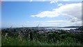
Larne, Bank Road
Larne is a seaport and industrial market town on the east coast of County Antrim. It has been used as a seaport for over 1000 years and today it is a major passenger and freight roll-on roll-off port.
Image: © David Dixon
Taken: 28 Sep 2017
0.23 miles
4

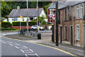
The Tullygarley mural, Larne (1)
The former “Sun” laundry which traded from the nearby Bank Road.
Image: © Albert Bridge
Taken: 14 Aug 2010
0.24 miles
5

The Tullygarley mural, Larne (2)
Weaving in a long-closed linen factory.
Image: © Albert Bridge
Taken: 14 Aug 2010
0.24 miles
6
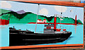
The Tullygarley mural, Larne (3)
The gun-running ship the “Clyde Valley”. She landed guns at Larne for use in the opposition to what was then called “Home Rule”.
Image: © Albert Bridge
Taken: 14 Aug 2010
0.24 miles
7
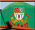
The Tullygarley mural, Larne (4)
In memory of the 36th Ulster Division http://en.wikipedia.org/wiki/36th_(Ulster)_Division
Image: © Albert Bridge
Taken: 14 Aug 2010
0.24 miles