IMAGES TAKEN NEAR TO
Glynn Road, LARNE, BT40 3AY
Introduction
This page details the photographs taken nearby to Glynn Road, BT40 3AY by members of the Geograph project.
The Geograph project started in 2005 with the aim of publishing, organising and preserving representative images for every square kilometre of Great Britain, Ireland and the Isle of Man.

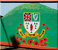
There are currently over 7.5m images from over14,400 individuals and you can help contribute to the project by visiting https://www.geograph.org.uk
Image Map
Images are licensed for reuse under creativecommons.org/licenses/by-sa/2.0
Notes
- Clicking on the map will re-center to the selected point.
- The higher the marker number, the further away the image location is from the centre of the postcode.
Image Listing (136 Images Found)
Images are licensed for reuse under creativecommons.org/licenses/by-sa/2.0
Image
Details
Distance
2
Larne Free Presbyterian Church of Scotland
A Free Presbyterian Church of Scotland http://www.fpchurch.org.uk/Beliefs/index.php at the corner of the Station Road and the Glynn Road. One of four congregations, in the UK, outside Scotland. Previously seen in Image September 2010.
Image: © Albert Bridge
Taken: 27 Jun 2012
0.08 miles
3
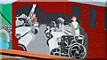
The Tullygarley mural, Larne (2)
Weaving in a long-closed linen factory.
Image: © Albert Bridge
Taken: 14 Aug 2010
0.09 miles
4
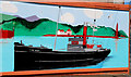
The Tullygarley mural, Larne (3)
The gun-running ship the “Clyde Valley”. She landed guns at Larne for use in the opposition to what was then called “Home Rule”.
Image: © Albert Bridge
Taken: 14 Aug 2010
0.09 miles
5
The Tullygarley mural, Larne (4)
In memory of the 36th Ulster Division http://en.wikipedia.org/wiki/36th_(Ulster)_Division
Image: © Albert Bridge
Taken: 14 Aug 2010
0.09 miles
6
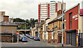
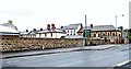
The Station Road, Larne
Larne was served by two railways – the narrow gauge line from Ballymena Image and the standard gauge line from Belfast York Road. The Station Road takes its name from the latter which was demolished to make way for the Harbour Highway and associated connecting roads Image Laharna House Image is the tall building in the background. The Google map is not accurate.
Image: © Albert Bridge
Taken: 13 Aug 2011
0.09 miles
7
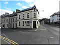
Free Presbyterian Church of Scotland, Larne
It is located at Station Road
Image: © Kenneth Allen
Taken: 25 Sep 2010
0.09 miles
8
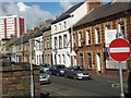
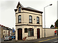
Station Road, Larne
The terraced houses in this road (which extends into Image) show a wide variety of fronts and sizes.
Image: © David Smith
Taken: 19 Sep 2012
0.09 miles
9

The Tullygarley mural, Larne (1)
The former “Sun” laundry which traded from the nearby Bank Road.
Image: © Albert Bridge
Taken: 14 Aug 2010
0.09 miles
10
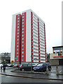
High rise flats, Larne
Looking south-west
Image: © Kenneth Allen
Taken: 15 Oct 2011
0.09 miles