IMAGES TAKEN NEAR TO
Gorse Meadow, LARNE, BT40 2QE

Introduction

This page details the photographs taken nearby to Gorse Meadow, BT40 2QE by members of the Geograph project.

The Geograph project started in 2005 with the aim of publishing, organising and preserving representative images for every square kilometre of Great Britain, Ireland and the Isle of Man.

There are currently over 7.5m images from over14,400 individuals and you can help contribute to the project by visiting https://www.geograph.org.uk

Image Map


Images are licensed for reuse under creativecommons.org/licenses/by-sa/2.0
Notes
  • Clicking on the map will re-center to the selected point.
  • The higher the marker number, the further away the image location is from the centre of the postcode.

Image Listing (16 Images Found)

Images are licensed for reuse under creativecommons.org/licenses/by-sa/2.0
Image
Details
Distance
1
Cairncastle National School
It is located along Cairncastle Road
Image: © Kenneth Allen Taken: 2 Jun 2010
0.08 miles
2
The Old Presbyterian Church, Cairncastle
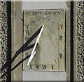
Located along the Cairncastle Road, there is an old sundial here, made in 1779 by Andrew Snody, still in perfect condition, see Image
Image: © Kenneth Allen Taken: 2 Jun 2010
0.09 miles
3
Sundial, Cairncastle
It is located on the front wall of the old Presbyterian Church Image]
Image: © Kenneth Allen Taken: 2 Jun 2010
0.09 miles
4
Cairncastle Road, Cairncastle
Heading south-west towards Matties Meeting House Pub on Brustin Brae Road which is in the adjoining square, see Image]
Image: © Kenneth Allen Taken: 2 Jun 2010
0.10 miles
5
Old Presbyterian Church, Cairncastle
This Non-subscribing Presbyterian Church was consecrated in December 1989. It stands on the site of a former church built in the seventeenth century.
Image: © Brian Shaw Taken: 19 Feb 2008
0.11 miles
6
Sundial
On the wall of the Old Presbyterian Church, Cairncastle. It bears the legend "By Andw Snody 1799". As can be seen, the time of the picture was just after 12:00 noon (Cairncastle Time).
Image: © Brian Shaw Taken: 19 Feb 2008
0.11 miles
7
Cairncastle, water pillar
On the village green; one of several noticed in the area. This one comes with bucket rest.
Image: © Mike Faherty Taken: 21 Jun 2018
0.14 miles
8
Cairncastle, Meeting House
Public house on Drumnagreagh Road, aka Matties. Small bar front, snug, lounge at back.
Image: © Mike Faherty Taken: 21 Jun 2018
0.15 miles
9
Cairncastle Orange Hall
On Drumnagreagh Road; dated 1954. Two large plaques on the front commemorate WWI.
Image: © Mike Faherty Taken: 21 Jun 2018
0.16 miles
10
Postbox, Cairncastle
Victorian wallbox (BT40 726) on the Drumnagreagh Road, Cairncastle.
Image: © Rossographer Taken: 1 May 2021
0.16 miles