
IMAGES TAKEN NEAR TO
Sallagh Lane, LARNE, BT40 2NF
Introduction
This page details the photographs taken nearby to Sallagh Lane, BT40 2NF by members of the Geograph project.
The Geograph project started in 2005 with the aim of publishing, organising and preserving representative images for every square kilometre of Great Britain, Ireland and the Isle of Man.

There are currently over 7.5m images from over14,400 individuals and you can help contribute to the project by visiting https://www.geograph.org.uk
Image Map
Images are licensed for reuse under creativecommons.org/licenses/by-sa/2.0
Notes
- Clicking on the map will re-center to the selected point.
- The higher the marker number, the further away the image location is from the centre of the postcode.
Image Listing (1 Images Found)
Images are licensed for reuse under creativecommons.org/licenses/by-sa/2.0
Image
Details
Distance
1
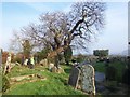
Legendary Tree - Cairncastle
St. Patrick's Church, beautifully situated on a height above the village of Cairncastle boasts a romantic local legend. Locals tell the tale of the body of a young nobleman, drowned when the defeated Spanish Armada fled along the coastline. His body was discovered by locals who buried him in the churchyard of St. Patrick's. From his grave a Spanish chestnut grew, possibly from seed hidden in his pockets. The tree is still there today, samples of which have been analysed and found to date back to the sixteenth century, giving credence to the local legend.
Image: © Brian Shaw
Taken: 19 Feb 2008
0.22 miles