IMAGES TAKEN NEAR TO
LARNE, BT40 1YE
Introduction
This page details the photographs taken nearby to BT40 1YE by members of the Geograph project.
The Geograph project started in 2005 with the aim of publishing, organising and preserving representative images for every square kilometre of Great Britain, Ireland and the Isle of Man.

There are currently over 7.5m images from over14,400 individuals and you can help contribute to the project by visiting https://www.geograph.org.uk
Image Map
Images are licensed for reuse under creativecommons.org/licenses/by-sa/2.0
Notes
- Clicking on the map will re-center to the selected point.
- The higher the marker number, the further away the image location is from the centre of the postcode.
Image Listing (217 Images Found)
Images are licensed for reuse under creativecommons.org/licenses/by-sa/2.0
Image
Details
Distance
1
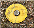
Survey mark, Larne
A York Survey Supply Centre http://www.yorksurvey.co.uk/ survey mark outside the tourist office on the Narrow Gauge Road.
Image: © Albert Bridge
Taken: 30 Jun 2013
0.01 miles
2
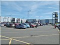
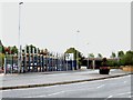
Larne, retail park
Laharna Retail Park, off Circular Road: http://www.morganwilliams.co.uk/out_of_town/scheme/Laharna-Retail-Park-Larne.html
Image: © Mike Faherty
Taken: 25 Jun 2018
0.04 miles
3
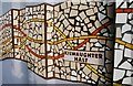
Mosaic, Larne
This mosaic, under the Harbour Highway flyover, commemorates the Larne Harbour – Ballymena narrow-gauge railway (1877-1950). Kilwaughter was the next station after Larne. Part of the road is built on the course of the line.
Image: © Albert Bridge
Taken: 15 Feb 2008
0.06 miles
4
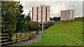
Riverside path, Larne
Part of a path, on reclaimed land as described in Image, alongside the Inver, between the Circular Road and the Station Road. The Riverdale Flats are in the background.
Image: © Albert Bridge
Taken: 13 Aug 2011
0.06 miles
5
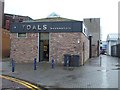
Toals Bookmakers, Larne
Looking east from Point Road
Image: © Kenneth Allen
Taken: 15 Oct 2011
0.06 miles
6
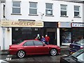
Linda's Caf? Boyles, Larne
It is located at Point Street
Image: © Kenneth Allen
Taken: 15 Oct 2011
0.07 miles
7
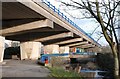
Elevated road, Larne
Part of the Harbour Highway is elevated as it bypasses the centre of Larne. The view is towards the harbour with the River Inver on the right.
Image: © Albert Bridge
Taken: 15 Feb 2008
0.07 miles
8
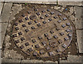
JC Hulse manhole cover, Larne (1)
A manhole cover, from the foundry of JC Hulse & Co Ltd http://www.geograph.org.uk/tags/?tag=person:J.C.%20Hulse&photo=2447662 under this flyover Image Image shows the maker’s name and address.
Image: © Albert Bridge
Taken: 13 Aug 2011
0.07 miles
9
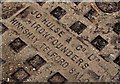
JC Hulse manhole cover, Larne (2)
See Image A close look at the maker’s name and address. The address differs from that in Image and Image
Image: © Albert Bridge
Taken: 13 Aug 2011
0.07 miles
10
The A2 approaching the A6 (Inver Road) Flyover at Larne
Image: © Eric Jones
Taken: 26 Sep 2013
0.08 miles