IMAGES TAKEN NEAR TO
Gullivers Road, BELFAST, BT3 9LU
Introduction
This page details the photographs taken nearby to Gullivers Road, BT3 9LU by members of the Geograph project.
The Geograph project started in 2005 with the aim of publishing, organising and preserving representative images for every square kilometre of Great Britain, Ireland and the Isle of Man.

There are currently over 7.5m images from over14,400 individuals and you can help contribute to the project by visiting https://www.geograph.org.uk
Image Map
Images are licensed for reuse under creativecommons.org/licenses/by-sa/2.0
Notes
- Clicking on the map will re-center to the selected point.
- The higher the marker number, the further away the image location is from the centre of the postcode.
Image Listing (20 Images Found)
Images are licensed for reuse under creativecommons.org/licenses/by-sa/2.0
Image
Details
Distance
1
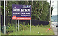
Giant's Park sign, Belfast - June 2017(2)
A second estate agents’ sign, beside the Dargan Road. This one refers to the development of a “CleanTech Hub” on part of the Giant’s Park site. The Belfast City Council website records “Commercial estate agents Lisney have been appointed to market the Environmental Resource Park to potential occupiers, investors and developers. A comprehensive campaign exposes the opportunities to local, national and international audiences” and “As well as making Belfast a world leader in green technology, the resource park, also known as a CleanTech Hub, will benefit citizens by: creating over 300 new jobs in green technologies open up new career opportunities, especially for young people and other disadvantaged groups deliver training and other opportunities during construction levering in additional private sector investment generate extra income for us, through rates and rents, which could be used to fund further development work at Giant’s Park and across the city help local businesses to boost productivity, drive efficiency and lower energy consumption developing greener, cheaper solutions for homeowners and businesses promote Belfast internationally.”
Image: © Albert Bridge
Taken: 22 Jun 2017
0.06 miles
2
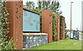
Entrance sculpture, the Giant's Park, Belfast (June 2017)
Part of the Giant’s Park has already been developed with the building of new film studios and access roads. This sculpture, at the Dargan Road entrance, features brent geese – birds which winter on Belfast Lough.
Image: © Albert Bridge
Taken: 22 Jun 2017
0.08 miles
3
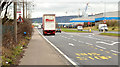
Dargan Road bus stop, Belfast
An outward stop, on the Dargan Road, served by the infrequent service no 96 Image Definitely not one of Translink’s busiest.
Image: © Albert Bridge
Taken: 20 Feb 2014
0.11 miles
4
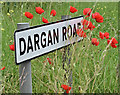
Poppies, Dargan Road, Belfast (June 2017)
Growing along the verge on the northern side of the Dargan Road.
Image: © Albert Bridge
Taken: 22 Jun 2017
0.14 miles
5
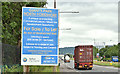
Giant's Park sign, Belfast - June 2017(1)
An estate agents’ sign, beside the Dargan Road, inviting expressions of interest for the development of the north foreshore former landfill site. The agents’ brochure includes “The Council wishes to invite Expressions of Interest from Developers with the experience and ability who would be interested in acquiring a site to build and manage a commercial leisure / mixed use development at the Giant’s Park North Foreshore. The Development Brief is a two stage process with initial expressions of interest being sought. Once these have been evaluated the successful parties will be notified to enable progression to Stage Two. Bid proposals will then be requested in accordance with a detailed set of criteria as set out in the Development Brief for consideration by Belfast City Council. A timetable for Stage Two of the process will be refined as the process progresses.”
Image: © Albert Bridge
Taken: 22 Jun 2017
0.14 miles
6
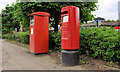
Pillar box and metered-mail box, Belfast
EIIR pillar box and metered-mail box on the Dargan Road, close to this disused one Image, on the Duncrue Road.
Image: © Albert Bridge
Taken: 7 May 2011
0.14 miles
7
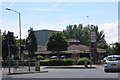
Dargan Road
The Portside Inn at the junction of Dargan Road and Duncrue Road in the Duncrue Industrial estate and docklands area.
Image: © Robert Ashby
Taken: 16 Jun 2014
0.16 miles
8
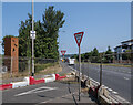
Signs, Belfast
Two 'Give Way' signs at Dargan Road, Belfast. They are joined by an 'EU Hands Off Ulster' sign - a large number of similar signs and graffiti appeared following the negotiation of the UK Brexit deal and Northern Irish Protocol. (An observation - closer to areas on the actual UK/EU border such as Image there is no trace of similar signs or graffiti).
Image: © Rossographer
Taken: 20 Jul 2021
0.16 miles
9
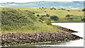
The north foreshore, Belfast Lough (June 2017)
The eastern/south eastern side of the Giant’s Park site.
Image: © Albert Bridge
Taken: 22 Jun 2017
0.17 miles
10

New access, Dargan Road, Belfast (May 2016)
The new access, opposite the Duncrue Road, to the North Foreshore (Giant’s Park) site. A new road is under construction out of picture.
Image: © Albert Bridge
Taken: 26 May 2016
0.18 miles