IMAGES TAKEN NEAR TO
East Twin Road, BELFAST, BT3 9EN
Introduction
This page details the photographs taken nearby to East Twin Road, BT3 9EN by members of the Geograph project.
The Geograph project started in 2005 with the aim of publishing, organising and preserving representative images for every square kilometre of Great Britain, Ireland and the Isle of Man.

There are currently over 7.5m images from over14,400 individuals and you can help contribute to the project by visiting https://www.geograph.org.uk
Image Map
Images are licensed for reuse under creativecommons.org/licenses/by-sa/2.0
Notes
- Clicking on the map will re-center to the selected point.
- The higher the marker number, the further away the image location is from the centre of the postcode.
Image Listing (273 Images Found)
Images are licensed for reuse under creativecommons.org/licenses/by-sa/2.0
Image
Details
Distance
1
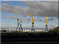
Cranes close to East Twin Road, Belfast Docks
Image: © HENRY CLARK
Taken: 15 Dec 2009
0.05 miles
2
![Scrapyard, Belfast [2]](https://s3.geograph.org.uk/photos/87/45/874523_847803dd_120x120.jpg)
Scrapyard, Belfast [2]
Scrapyard at the northern end of Queen's Island in Belfast. A lot of the scrap metal processed here is shipped out of Belfast - see Image The crane in the background is around the Belfast Dry Dock - see Image See also Image and Image
Image: © Rossographer
Taken: 4 Jul 2008
0.06 miles
3
Cranes close to East Twin Road, Belfast Docks
Image: © HENRY CLARK
Taken: 15 Dec 2009
0.06 miles
4
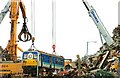
Train scrapping, Belfast
NIR railcar 8086 reaches the end of the line at the Clearways scrapyard in Belfast harbour. It will probably be melted down in Spain where, by one of those coincidences, its successors Image were built.
Image: © Albert Bridge
Taken: 9 Jul 2008
0.07 miles
5
![Scrapyard, Belfast [1]](https://s0.geograph.org.uk/photos/87/45/874520_8a19461d_120x120.jpg)
Scrapyard, Belfast [1]
Scrapyard at the northern end of Queen's Island in Belfast. A lot of the scrap metal processed here is shipped out of Belfast - see Image The cranes in the background are around the Belfast Dry Dock - see Image See also Image and Image
Image: © Rossographer
Taken: 4 Jul 2008
0.07 miles
6
The 'Queen Victoria' at Belfast
The luxurious Cunard cruise ship 'Queen Victoria' https://www.marinetraffic.com/en/ais/details/ships/shipid:3726902/mmsi:310624000/imo:9320556/vessel:QUEEN_VICTORIA just poking up above various skips and trailers from the scrapyard on East Twin Road in Belfast. The ship is currently dry-docked at Harland & Wolff, Image is a more impressive view.
Image: © Rossographer
Taken: 17 May 2022
0.08 miles
7
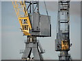
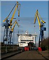
Harland & Wolff Shipbuilders - Belfast
You can clearly see the two large yellow cranes at Harland & Wolff's shipyard - they are called Samson and Goliath.
Image: © Ian Rainey
Taken: 17 Sep 2016
0.09 miles
8
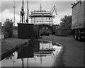
East Twin Road, Belfast
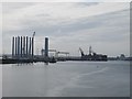
East Twin Road is a very short cul-de-sac in Belfast docks. Located at the end of Queen's Island, it is used almost exclusively by the scrap metal works (located, unseen, to the right of picture - see Image, Image and Image). The red skips are used by the scrap metal works who, aware that there is virtually no other traffic, use the road to store the empty skips.
Dominating the picture, however, are three enormous cranes and the bow of a very large ship. Directly ahead of East Twin Road is the Belfast Dry Dock - see Image and a variety of related images at http://www.geograph.org.uk/search.php?i=5511034 . Seen in this picture is the 'Stena Adventurer', a 211m passenger/vehicle ferry which is being serviced in the dock. This vessel normally operates on the Dublin-Holyhead route see Image and Image The dry dock cannot be accessed from the East Twin Road - it actually lies on the adjacent Workman Road but this is private property and has no public access.
Image: © Rossographer
Taken: 5 Mar 2009
0.09 miles
9
![Scrapyard, Belfast [3]](https://s1.geograph.org.uk/photos/87/45/874525_36e462ce_120x120.jpg)
Scrapyard, Belfast [3]
Scrapyard at the northern end of Queen's Island in Belfast. A lot of the scrap metal processed here is shipped out of Belfast - see Image See also Image and Image
Image: © Rossographer
Taken: 4 Jul 2008
0.09 miles
10
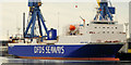
The "Hibernia Seaways" at Belfast
The Belfast – Heysham freight ferry the “Hibernia Seaways” at the Ship Repair Quay, Harland & Wolff. (Note: the Google map and the satellite photo differ significantly here).
Image: © Albert Bridge
Taken: 29 Jan 2011
0.10 miles