IMAGES TAKEN NEAR TO
Queens Road, BELFAST, BT3 9DT
Introduction
This page details the photographs taken nearby to Queens Road, BT3 9DT by members of the Geograph project.
The Geograph project started in 2005 with the aim of publishing, organising and preserving representative images for every square kilometre of Great Britain, Ireland and the Isle of Man.

There are currently over 7.5m images from over14,400 individuals and you can help contribute to the project by visiting https://www.geograph.org.uk
Image Map
Images are licensed for reuse under creativecommons.org/licenses/by-sa/2.0
Notes
- Clicking on the map will re-center to the selected point.
- The higher the marker number, the further away the image location is from the centre of the postcode.
Image Listing (377 Images Found)
Images are licensed for reuse under creativecommons.org/licenses/by-sa/2.0
Image
Details
Distance
1
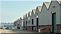
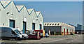
Channel Commercial Park, Belfast - April 2019(3)
See Image “Pinebank” (right) and “Ashbank” warehouses, from the Queen’s Road.
Image: © Albert Bridge
Taken: 21 Apr 2019
0.02 miles
2
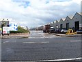
Channel Commercial Park
The park offers 350,000 square feet of storage space.
Image: © Michael Dibb
Taken: 27 Jul 2017
0.03 miles
3
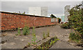
Old shipyard wall, Belfast (3)
A surviving part of a former Harland & Wolff building, on the eastern side of the Queen’s Road.
Image: © Albert Bridge
Taken: 21 Aug 2011
0.04 miles
4
![Shipyard sculpture, Belfast [1]](https://s0.geograph.org.uk/photos/77/54/775484_c36d73bb_120x120.jpg)
Shipyard sculpture, Belfast [1]
Standing at the side of the Queen's Road at the entrance to Channel Commercial Park, this sculpture is called 'Blinks' and is a tribute to the shipyard workers of Belfast.
The sculpture was 'facilitated' by artist Peter Nelson but designed and constructed by former shipyard welders themselves. The sculpture is based on the working lives of men in the shipyards and details the various trades of the workers.
The piece gets its name from the 'blinks', an irritation of the eye caused by watching the arc light of the welding torch for too long. It has been likened to having sand thrown in your eyes.
Image: © Rossographer
Taken: 23 Apr 2008
0.04 miles
5
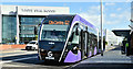
Glider bus, Titanic Quarter, Belfast (September 2018)
Glider Van Hool Equi City rapid transit bus (3215 HGZ 8215) about to depart from the Catalyst halt, Queen’s Road with the 10.50 to Wellington Place.
Image: © Albert Bridge
Taken: 3 Sep 2018
0.04 miles
6
Channel Commercial Park, Belfast - April 2019(2)
See Image “Elmbank” (left) and “Oakbank” warehouses, from the Queen’s Road.
Image: © Albert Bridge
Taken: 21 Apr 2019
0.05 miles
7
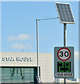
"Your speed" sign, Titanic Quarter, Belfast (September 2018)
Solar-powered speed limit sign, on the Queen’s Road, just past the entrance to the Alexandra Dock and HMS “Caroline”. The Queen’s Road is part of the harbour estate but with full public access. Speed limits and traffic by-laws are set by the Harbour Commissioners and enforced by the Harbour Police https://en.wikipedia.org/wiki/Belfast_Harbour_Police
Image: © Albert Bridge
Taken: 3 Sep 2018
0.05 miles
8
Channel Commercial Park, Belfast - April 2019(1)
Modern warehousing, between the Queen’s Road (foreground) and the Musgrave Channel Road, built on the site of the former Harland & Wolff Thompson Dock Works. Part of the Titanic Quarter. See also Image and Image
Image: © Albert Bridge
Taken: 21 Apr 2019
0.05 miles
9
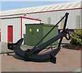
Anchor, Belfast
This anchor looks very similar to those seen in Image It has been used as a feature in Channel Commercial Park (not yet on the Google maps) at Queen's Island.
Image: © Rossographer
Taken: 19 May 2008
0.05 miles
10
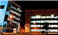
Titanic Quarter buildings, Belfast (1)
Image: © Albert Bridge
Taken: 6 Jan 2011
0.06 miles