IMAGES TAKEN NEAR TO
Junction Lane, BALLYCLARE, BT39 9UU
Introduction
This page details the photographs taken nearby to Junction Lane, BT39 9UU by members of the Geograph project.
The Geograph project started in 2005 with the aim of publishing, organising and preserving representative images for every square kilometre of Great Britain, Ireland and the Isle of Man.

There are currently over 7.5m images from over14,400 individuals and you can help contribute to the project by visiting https://www.geograph.org.uk
Image Map
Images are licensed for reuse under creativecommons.org/licenses/by-sa/2.0
Notes
- Clicking on the map will re-center to the selected point.
- The higher the marker number, the further away the image location is from the centre of the postcode.
Image Listing (3 Images Found)
Images are licensed for reuse under creativecommons.org/licenses/by-sa/2.0
Image
Details
Distance
1
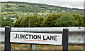
Junction Lane name sign, Ballybracken, Ballynure/Larne (July 2017)
The name sign on a lane connecting the dual carriageway Larne Road to the minor Junction Road. The name comes from the nearby former Ballyboley Junction https://en.wikipedia.org/wiki/Ballyboley_Junction_railway_station on the long-closed narrow-gauge Larne - Ballymena railway Image The lane is not shown on the Google map.
Image: © Albert Bridge
Taken: 2 Jul 2017
0.07 miles
2
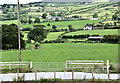
Gates and fields, Ballybracken, Ballynure/Larne (July 2017)
Gates and fields, forming typical east Antrin scenery, on the western side of the Larne Road, at Junction Lane Image
Image: © Albert Bridge
Taken: 2 Jul 2017
0.11 miles
3
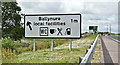
Advance direction sign, Ballybracken, Ballynure/Larne (July 2017)
Advance direction sign, approaching the minor Ballybracken Road Image, along the Larne Road dual carriageway.
Image: © Albert Bridge
Taken: 2 Jul 2017
0.20 miles