IMAGES TAKEN NEAR TO
Straid Road, BALLYCLARE, BT39 9PY
Introduction
This page details the photographs taken nearby to Straid Road, BT39 9PY by members of the Geograph project.
The Geograph project started in 2005 with the aim of publishing, organising and preserving representative images for every square kilometre of Great Britain, Ireland and the Isle of Man.

There are currently over 7.5m images from over14,400 individuals and you can help contribute to the project by visiting https://www.geograph.org.uk
Image Map
Images are licensed for reuse under creativecommons.org/licenses/by-sa/2.0
Notes
- Clicking on the map will re-center to the selected point.
- The higher the marker number, the further away the image location is from the centre of the postcode.
Image Listing (2 Images Found)
Images are licensed for reuse under creativecommons.org/licenses/by-sa/2.0
Image
Details
Distance
2
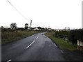
New road junction
The B58 Carrickfergus Road where it splits in two. Running from left to right in the backgroung is the new bypass to the A8. The photo was taken from the old part of the B58 leading to the village of Ballynure. Part of the Larne Road dualling scheme.
Image: © Robert Ashby
Taken: 6 Feb 2014
0.25 miles