IMAGES TAKEN NEAR TO
Greenwood Avenue, BALLYCLARE, BT39 9PN
Introduction
This page details the photographs taken nearby to Greenwood Avenue, BT39 9PN by members of the Geograph project.
The Geograph project started in 2005 with the aim of publishing, organising and preserving representative images for every square kilometre of Great Britain, Ireland and the Isle of Man.

There are currently over 7.5m images from over14,400 individuals and you can help contribute to the project by visiting https://www.geograph.org.uk
Image Map
Images are licensed for reuse under creativecommons.org/licenses/by-sa/2.0
Notes
- Clicking on the map will re-center to the selected point.
- The higher the marker number, the further away the image location is from the centre of the postcode.
Image Listing (5 Images Found)
Images are licensed for reuse under creativecommons.org/licenses/by-sa/2.0
Image
Details
Distance
1
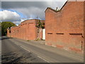
Green Road Factory
This commanding red brick structure is derelict, with no external signage to give a clue to its earlier purpose
Image: © Raymond Okonski
Taken: 27 Sep 2007
0.05 miles
2
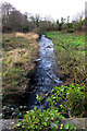
Green Burn
Green Burn is a little stream which runs alongside Green Road in Ballyclare.
Image: © Robert Ashby
Taken: 6 Feb 2014
0.17 miles
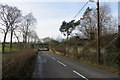
3
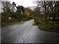
The Green Road, Ballyclare
The Green Road (part of the B95) on the outskirts of Ballyclare.
Image: © Rossographer
Taken: 19 Nov 2009
0.17 miles
5
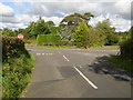
Green Road Ballyclare
A row of derelict cottages beside Green Road. The bridge ahead carries the Templepatrick Road past Ballyclare.
Image: © Robert Ashby
Taken: 6 Feb 2014
0.23 miles